The Klondike observing site
finalized April 2006
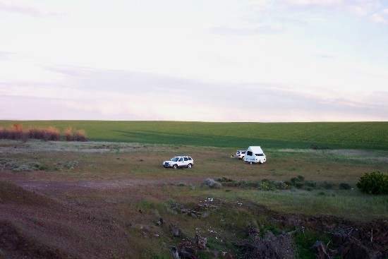
The Klondike site in April '03. If you darken the image,
the wind turbines become visible on the center horizon.
A few years back I picked up a BLM map of north-central Oregon and sought out
'gravel
pit's and 'rock quarry's, presuming them to be reasonably public. The site,
just north of a few buildings labeled "Klondike" on the Oregon Atlas maps, was
my second stop that day and appeared promising. I have viewed from here on
several occasions and always left happy. The first visit was the worst, with a
steady west wind; considering that my return trip to Portland was through
driving rains in the gorge to overcast skies in town, it was still very good in
my book!
This observing site is an easy drive from Portland and is about seven miles west
of Wasco, south of Rufus and Interstate 84. It has several things going for it
in my judgement; these include:
- two-hour drive from my home in NE Portland
- no visible light sources for miles
- very little skyglow
- minimal traffic
- just over one mile of unpaved road
Other potential positives are its proximity to Wasco and its [limited]
amenities, and Biggs (fuel, restrooms, junk food, 24-hour restaurant!). On the
down side, it has proven to be windy on days with a west wind in the gorge. Its
eleveation is about 1400 feet, so it's low compared to most summer sites but
just right for off-season visits.
Directions
Travel east on Interstate 84 through the Dalles. Exit at Biggs [exit 104] and
go south on US 97 after stocking up on goodies. Two junctions are available to
reach Wasco: a cryptic sign at around 7˝ miles leads left then south, or an exit
on Oregon 208 a mile or so further works even better. This second junction
meets the first road in the center of town. The road to the airport continues
east where the roads meet. Follow the airport road for 4+ miles until it ends
at a T-junction, where you go left. One mile further, turn right on unpaved
Dehler Lane. About 1.5 miles ahead an opening appears to the right; it's marked
as a gravel pit on my map, but it's just an open area that extends a hunderd
yards or so south. It always comes as a surprise when the site appears, as the
entire area is nothing but farmland - but trust me, the site will appear!
Comparing this site to the reasonably-nearby site at Tygh Ridge:
- Tygh has lower horizons, almost negative! Klondike is a shallow bowl with
very good horizons.
- Tygh has light bubbles from the Dalles, PDX, also glow from ? both south and
east. In my most recent visit to Klondike I the glow from the rotating local
airstrip beacon, and very low light bubbles from the Dalles (west), Goldendale
and/or Rufus (north) and Arlington (east). Only two actual points of light are
visible from near the road, appearing no brighter than 4th magnitude.
- Klondike is less than ten minutes from Wasco, about fifteen to Biggs or
Rufus on I-84, so amenities are pretty close. Dufur is the closest town to Tygh
Ridge, at least twenty minutes away.
- It's a breezy spot when the wind is from the west. I suspect that Tygh Ridge
is less influenced by the Columbia River Gorge winds but at 4000 feet has its
own sources.
I believe the most traffic I have seen was two cars on Dehler Lane on one night.
The site has the added benefit of entry from the north, so any cars traveling
on that road are generally not in the most troublesome direction. It also sits
squarely in agricultural fields, and I suspect that Sherman County won't be
seilling this off for development in the near future. The potential bad news:
last time I was there I did see evidence that is occasionally used as
target-practice area for beer-can hunters, so as usual, it's best not to visit
alone.
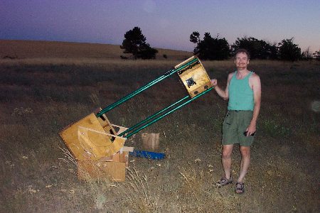 The 2-meter telescope had an early
test-run at Klondike..
The 2-meter telescope had an early
test-run at Klondike..
2003 Updates
Sherman County now has a
use for that empty space: wind energy! A wind farm has taken up residence
a few miles from this site, and flashing beacons warn air traffic to avoid the swirling
blades. Just goes to show that one person's definition of non-polluting energy may not
apply to others. It is still a good site, though - the wind turbines as of May 03 are not
visible from the observing area. Ominously, however, the current setup is listed as
"Klondike Phase I" - which suggests that more will appear in the future. As a fan of
renewable energy and astronomy, I see value in both efforts, and hopefully the site will
not be harmed by future projects. I have learned that Phase II will be south of the
current turbines, so in the near term the site is not at risk.
Interesting news from Klondike - it turns out to be a privately-owned spot!
Several observers were there in late October and encountered family members who
were investigating nearby gunshots. Thankfully, the owner is happy to share the
spot with our group. It's a relief to know this, since all this time I had mistakenly
presumed it to be a public spot owing to its designation on a BLM map. Live and learn!
Update from an RCA member..
Sent: Sunday, April 02, 2006 4:45 PM
On a very sad note -
I swung by the Klondike observing site, just to see what was going on there. The new series of wind towers (and they are really, really tall) tromp right through the observing field. Where the grassy place used to be is now an access road. The towers march south for several miles with the conga line starting four towers north of the observing field.
Time to retire the site with honors