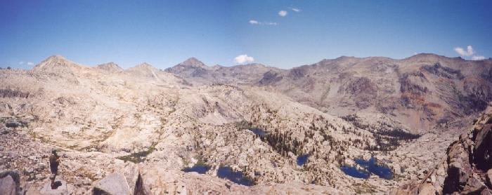
panorama from Blue Canyon Pass, Day 5; Del at lower left
The Sierra 2001 North Fork Kings River Expedition is in the books! It was a
strong workout that began in difficult weather, but by the fifth day the skies
were non-threatening if not always 100 percent clear. It was a great event that
set set several personal bests or firsts - I only
wish the fishing gear had come along!
Total distance was approximately 70 miles, with 45-plus on trails to and from
the Portal Lake area. Ten more were cross-country or on rough paths with packs
on, and three day-hikes added another fifteen miles. Here are the rough daily
stats:
| Day 1 | trailhead to Chimney Lake | 11 mi |
| Day 2 | to Halfmoon Lake | 7 mi |
| Day 3 | below Portal Lake | 6 mi |
| Day 4 | x-c to Hummingbird Lake | 5 mi |
| Day 5 | day-hike to Blue Cyn Pass | 7 mi |
| Day 6 | x-c to Pearl Lake | 6 mi |
| Day 7 | day-hike to Valor Pass | 8 mi |
| Day 8 | to Crown Creek | 12 mi |
| Day 9 | to a different trailhead?!? | 10 mi |
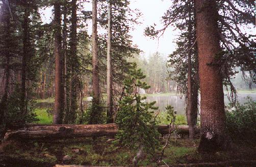
Day One began early - 3AM to be precise - when a frog landed in my ear. While such things can happen when one uses a rainfly without the tent, I would think it quite rare, and it's a very surprising thing to find in one's ear at any time. It sure felt like a frog when I moved it out of my ear, and my headlamp confirmed the suspicion. At least I was sleeping on my side, since he could easily have choked me otherwise! Other than that surprise, and the off/on rain showers, I slept fairly well. We awoke and dined early, then departed for the trailhead in a fog - really! When we finally found the road over Wishon Dam, we were unable to see the far side of the reservoir, which is unsettling on a one-lane road. We could barely even see the water in the reservoir itself. We finally made it across, up the paved and unpaved road, and reached the trailhead. We saw no sign of Dan, but for the first few days we held out hope that he would catch up to us (as our route changed, our comments mutated into variations of "Dan must be getting mad since we're not where we agreed to be!").
| It began to rain again as we made our final preparations, so rain gear was added to the mix - ponchos for Del and Frank, a parka and hat for me (packed at the last minute after checking the extended forecast), and a red umbrella for Bill. Soon we were off, trudging uphill through thick manzanita shrubs that hid our feet and whipped our shins. Frank's gaiters were a clear winner on this stretch, which ended at the two-mile mark. Here we met a trio coming out, ending their long trip under several days of rain. We plodded onward to the junction by Finger Rock, and rested at a meadow that provided us with a nice view of the granite spike. Two day-riders on horses pulled in, conversed with us a moment, then turned around, and we soon moved onward. Bill suggested a route change, so we turned left toward the Woodchuck Trail instead of aiming for Chuck Pass. Two more hikers drifted by with large packs: their plans had changed after two days of stormy weather, and they wished us better luck than theirs. The day dragged on with more showers and perpetual clouds, and when we reached the Chimney Lake junction it was clear that we'd be stopping very soon. We reached the lake and found a nice camp, complete with a large fire ring and even a horse-camp toilet a few minutes away. I wish I could remember more about this first evening, but clearly I was exhausted... |
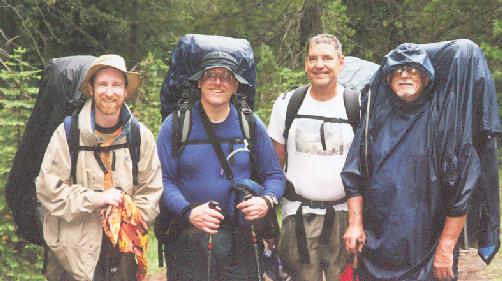 the fearsome foursome?
|
|---|
Day Two dawned bright and clear, and stayed that way for nearly twenty minutes. Before
breakfast was cooked, cumulus clouds were piling up, thanks to all the moisture
on the ground. We dried our gear as best we could, packed up and moved on
toward Crown Pass. We met another couple on their way out, and a train of
horses with two men crossed our path on the way to Woodchuck Lake. We
couldn't know it at the time, but at 9AM on day two we had just seen the last
people we would see on the entire trip! Just before reaching the Crown
Valley trail we came to a nice viewpoint that showed Crown Lake and some granite
scenery below a broken-overcast sky. We reached Crown Pass within ten minutes,
and the thunder began to growl within fifteen. Halfmoon Lake became our
destination for the day, and Bill and Del raced ahead to beat the storm to a
campsite. Frank and I kept to our pace and were rewarded with a full selection
of weather - hail, wind and wind gusts played over thunderous percussion as we
worked our way to the lake.
 We found the others at a nice spot, and I threw my
rainfly over a fairly dry patch of ground to keep it from further wetting. The
showers relented, and we celebrated with another roaring fire to dry our things
and warm our spirits. Just before dinner another thundershower hit, and Bill
guarded the fire with his umbrella until the heat drove him away; by then we had
dried enough wood, and the wind from the storm actually improved the fire's
circulation!
We found the others at a nice spot, and I threw my
rainfly over a fairly dry patch of ground to keep it from further wetting. The
showers relented, and we celebrated with another roaring fire to dry our things
and warm our spirits. Just before dinner another thundershower hit, and Bill
guarded the fire with his umbrella until the heat drove him away; by then we had
dried enough wood, and the wind from the storm actually improved the fire's
circulation!
 I hate to say this in a public forum, but: Halfmoon Lake is a destination
spot all by itself. A gorgeous gem at the base of an anonymous peak
(Scepter Peak, named only on the 7˝' map), it has lovely tall trees, at least
one great campsite, and plenty of pan-size trout drifting along the shoreline in
search of misplaced bugs. It was a very pretty spot, and having it to ourselves
was surprising to me. Let's not all go there at once, though, OK?
I hate to say this in a public forum, but: Halfmoon Lake is a destination
spot all by itself. A gorgeous gem at the base of an anonymous peak
(Scepter Peak, named only on the 7˝' map), it has lovely tall trees, at least
one great campsite, and plenty of pan-size trout drifting along the shoreline in
search of misplaced bugs. It was a very pretty spot, and having it to ourselves
was surprising to me. Let's not all go there at once, though, OK?
Day Three began as another gorgeous morning, but we knew the area was holding more
moisture than would be good for us.
 Another valiant attempt to dry our gear was followed by a gentle trip east
toward the North Fork Kings. This area was deeply forested and fairly dry, but
Bill warned of swampier conditions ahead. The bugs made their first serious run
at us here, but our deterrents were for the most part effective. We reached the
North Fork and ate lunch, then set up our cameras for group photos. From there
we moved upstream, into just what Bill had promised: swampland. The recent
rainfall had not improved things, and just to be sure the cumulus clouds were
fully developed by noon. We crawled through the area at our best pace toward
Portal Lake, admiring the beautiful North Fork while swatting dozens of
mosquitoes and sinking in the muck. As we worked up the smaller stream to
Portal Lake the rain began again, and as before Bill and Del found us a good
site which Frank and I reached as the storm struck.
Another valiant attempt to dry our gear was followed by a gentle trip east
toward the North Fork Kings. This area was deeply forested and fairly dry, but
Bill warned of swampier conditions ahead. The bugs made their first serious run
at us here, but our deterrents were for the most part effective. We reached the
North Fork and ate lunch, then set up our cameras for group photos. From there
we moved upstream, into just what Bill had promised: swampland. The recent
rainfall had not improved things, and just to be sure the cumulus clouds were
fully developed by noon. We crawled through the area at our best pace toward
Portal Lake, admiring the beautiful North Fork while swatting dozens of
mosquitoes and sinking in the muck. As we worked up the smaller stream to
Portal Lake the rain began again, and as before Bill and Del found us a good
site which Frank and I reached as the storm struck.
We had almost five minutes to select dry tentsites and nail down our gear before
the hail began. Bill had stashed some relatively dry wood under the trees, but
everything was soaked again very soon. As the thunder arrived for our
entertainment, I checked my campsite only to discover it was not staying dry in
the least, so I shifted to a less enchanting but more protected spot. I erected
the poles from underneath the fly to stay drier, but when I was finished the
rain had increased and my hands and gloves were thoroughly soaked. I rejoined
the others by the fire ring, and we waited another half-hour before the rain,
hail and thunder relented. This time the fire (with some white-gas coaxing) had
plenty of work to do, as so much gear needed to dry.
 Clearly we could not
continue the trip much longer if the cumulative dampness reached our vital gear,
so I was apprehensive as the storms lingered nearby. After an excellent pasta
dinner and with hands and gloves working again, I was much relieved to see
sunlight return late in the day. I resolved to visit Portal Lake, but the large
meadow by the camp steered me toward a rocky ridge instead. Figuring I would
see the lake just as well from there, I clambered upward to an excellent view of
the southern end of Blackcap Basin. While only two mountains in sight had
actual names, the area is serrated with 12000-foot peaks whose impression is
undiminished by their anonymity. I shot many photos and video sequences from
the ridgetop, and managed to glimpse Portal Lake in its sheltered vale. As the
sun set over the Three Sisters (in the Dinkey Lakes area) I took a few final
shots and descended back to camp. If the trip failed, I had at least seen the
high country up close; however, I wasn't ready to fail just yet.
Clearly we could not
continue the trip much longer if the cumulative dampness reached our vital gear,
so I was apprehensive as the storms lingered nearby. After an excellent pasta
dinner and with hands and gloves working again, I was much relieved to see
sunlight return late in the day. I resolved to visit Portal Lake, but the large
meadow by the camp steered me toward a rocky ridge instead. Figuring I would
see the lake just as well from there, I clambered upward to an excellent view of
the southern end of Blackcap Basin. While only two mountains in sight had
actual names, the area is serrated with 12000-foot peaks whose impression is
undiminished by their anonymity. I shot many photos and video sequences from
the ridgetop, and managed to glimpse Portal Lake in its sheltered vale. As the
sun set over the Three Sisters (in the Dinkey Lakes area) I took a few final
shots and descended back to camp. If the trip failed, I had at least seen the
high country up close; however, I wasn't ready to fail just yet.
Day Four was a transition day in several respects. We were now heading off-trail into
Crown Basin, aiming toward Mantle Pass and the upper reaches of Blue Canyon.
 We
were also departing from our 'plans' [of which we had few!] since the weather and our pace had put us a day behind
schedule. Last and not least, Bill was departing from our group, as he had an
appointment to keep two days later. The bright morning sunshine dried our gear
in good time, and soon we were looking for the path to cross into Crown Basin.
Once found, the path led us over a small divide to the uppermost basin, whose
waters would drain into the Middle Fork Kings. The trail promptly vanished, but
we knew the way well enough from here, and Crown Basin is perfect Sierra Nevada
cross-country terrain: sheets of granite, sporadic trees, and water in every
draw.
We
were also departing from our 'plans' [of which we had few!] since the weather and our pace had put us a day behind
schedule. Last and not least, Bill was departing from our group, as he had an
appointment to keep two days later. The bright morning sunshine dried our gear
in good time, and soon we were looking for the path to cross into Crown Basin.
Once found, the path led us over a small divide to the uppermost basin, whose
waters would drain into the Middle Fork Kings. The trail promptly vanished, but
we knew the way well enough from here, and Crown Basin is perfect Sierra Nevada
cross-country terrain: sheets of granite, sporadic trees, and water in every
draw.
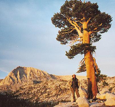
We unfortunately picked the toughest route to our goal (Hummingbird Lake on the 7˝' quad), going up the green draw north of the lake. Del and Bill again took the lead, and Frank and I lost sight of them after a particularly steep stretch. We knew where we had to go and continued plodding forward, and crossing the high point we saw Del below us near the lake. Bill had stepped away and was heading east on his own, but we didn't know to look that way for him. When we reached the lake Del had scouted out a few tent sites and informed us that Bill was gone. We would have liked to say goodbye, but he needed to move fast to keep his appointment so clearly he couldn't wait for us. I crossed the creek and found an interesting camp, then counted fish along the shore. This small lake had Halfmoon Lake beat: I could see eight pan-sized trout at one time, prowling the shore for treats! The clouds had gathered yet again, but kept losing strength before reaching us; only a light shower actually reached our camp this day, giving us high hope for the next day's trip through Blue Canyon. As the clouds broke after dinner we remaining three wandered west along the slope, exploring the country in all directions. Del reported the route west from the lake looked much better than the way we had chosen, and we agreed to leave that way when we left on day six.
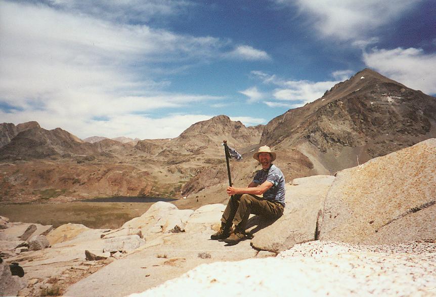
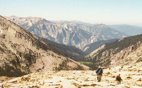
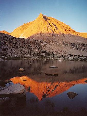
Day Five had mutated from the original 'plan'. What had been a tough packing day over Mantle and Blue Canyon Passes would now be a full day-hike to Blue Canyon Pass and back - much more relaxing and easier on the legs. My left knee was saying unpleasant things about the trip so far, so a light day with an Ace bandage seemed like a fine idea. The day-pack was full of foul-weather gear, just in case. By leaving camp intact we were able to start early, and an hour after starting we reached the final climb to Mantle Pass. Two options present themselves here, and Del took the direct route while Frank and I took the grassy slot to the north. Both proved uncomplicated, and we met by the shore of the unnamed lake on the east side. Nearly a dozen birds were chirping merrily here, prompting me to suggest Songbird Lake as its name - a good complement to Hummingbird Lake on the other side. We stayed pretty close to 11000 feet as we crossed into uppermost Blue Canyon, and for the most part it was a good idea. The views were spectacular, and none of us had maps of sufficient scale to determine the identities of the more distant peaks. The Gorge of Despair seemed pretty obvious, though - those ragged spires soaring beyond the green meadows of lower Blue Canyon were in just the right place for good visibility. As we worked around Finger Peak toward the pass, the sidehill slope became awkward, and we knew the return route would not be up this high. Still, it was not long before we stood at Blue Canyon Pass, looking down on remote lakes and across to the south face of Mt. Goddard.
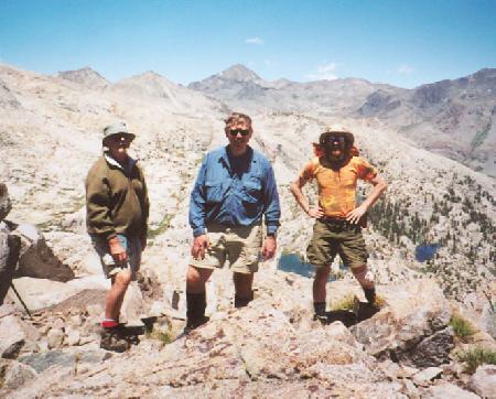
the remaining three at Blue Canyon Pass, Goddard in back
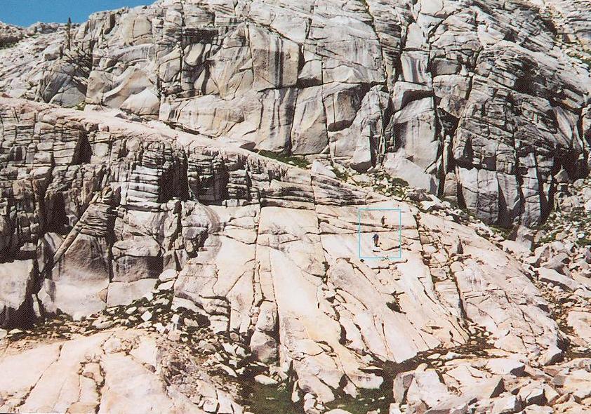
Two climbing the Ramp
(in the box)!
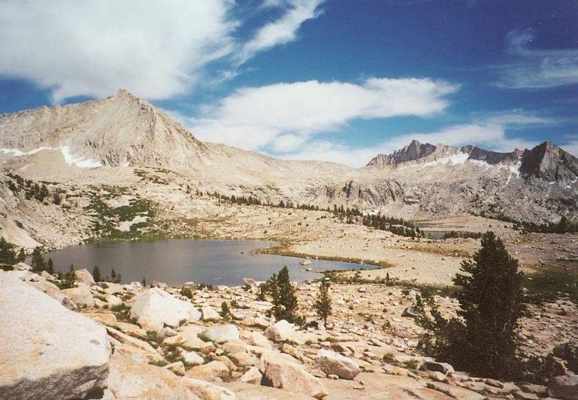
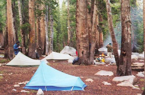
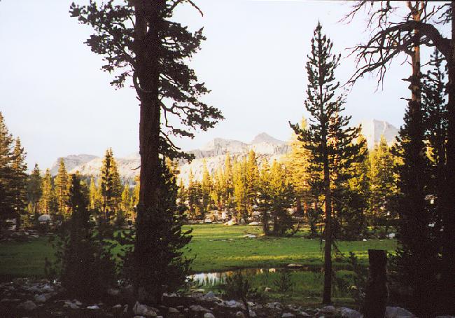
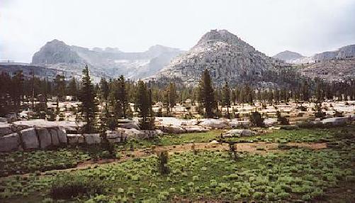
Day Six found us re-shouldering our packs for the northward walk. We had decided to relocate our camp farther north near Pearl Lake, hoping to day-hike again toward our old goal of Valor Pass in order to see as much of Blackcap Basin as possible. The trip down-creek was as Del had foreseen - other than a few willow-bushes it was a gradual drop to the lower end of Crown Basin. This area is delightfully underrated in the books, given little press but well worth further exploration. We wandered up-basin and reconnected with the path toward Portal Lake. When we reached the intersection we hopped over Portal's outlet stream and continued northeast, following the occasional irrelevant duck toward Peral Lake. A final steep stretch leveled out on a pretty plateau that held the relatively large Pearl Lake, a few whitebark pines, and plenty of scenery. Del and I scouted for camps while Frank recorded the exquisite views, and we found a nice spot for a two-day stay.
The clear skies and warm afternoon convinced me to spend this night under the stars, and I rolled out my bag in a sheltered spot. The sunset was spectacular, with the sharp western spur of peak 12323 dominating the view. I had hoped to climb the east side of that peak from the other side, but plans change, and I would not have ventured out to that spur in any case!
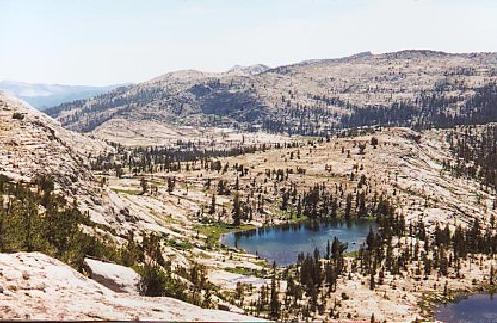
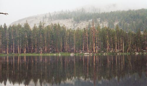
Sunset at Pearl Lake

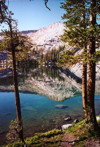
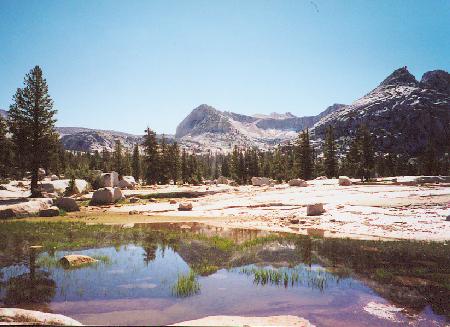
Chapel Lake Basin above Portal Lake
Day Seven was both spectacular and difficult due to a poor night's sleep. My bedroll was on a slope, so my feet became chilled until I reversed my sleeping position. Soon thereafter I noted a rather thick frost forming on the bag; while the bag kept me warm and dry through the night, the frost was heavy and distracting, costing me more sleep. I awoke groggy and grumpy, setting me up poorly for a full day's hiking.
We first climbed north to Division Lake, still slumbering in the shadow of its cliffs. A zig east to Regiment Lake was followed by a zag above Ram and Ewe Lakes - and then it hit me. Directly in front of us loomed Mt. Reinstein, a goal even more enticing than Valor Pass ! I tried to ignore its siren song (different from the historical sirens Scylla and Charybdis, whose peaks loom a few miles further east), but it kept working on me. Trouble is, a group of three doesn't divide well at all, and Frank wasn't smitten by Reinstein's song, so after an internal struggle I postponed the climb until later. Dropping to Bighorn Lake we veered eastward again, up to impressive Ambition Lake. While the route didn't look appealing from here, we followed the topo map's guidance northeastward and found a good route to Valor Lake, from which any short walk north or east leads to a steep drop to uppermost Goddard Canyon and Martha Lake. Within twenty minutes we stood on the brink and looked about in amazement.
| WHAT A VIEW. First and foremost stands the dark sentinel of Mount Goddard, with cliffs strewn about its eastern flanks to guard the summit 1600 feet above. Directly between and nearly 1000 feet below us, Martha Lake marks the start of the San Joaquin's south fork, and Goddard Canyon drew our gaze northward. Goddard's satellite peaks, clad in both dark and rusty red rock, were equally intimidating in appearance, blocking views of adjacent valleys. Amazingly enough, through a gap to the northeast a still-larger peak revealed itself: Mount Humphreys is a distinctive peak from all directions and showed itself unmistakably even from this distance. It was not the only distant peak, though, with Seven Gables and Gemini standing tall above the east wall of Goddard Canyon, and Black Giant poking up just to Goddard's right. Mt. Reinstein covered the skyline to the southwest, while Scylla and the Ragged Spur presented another dark face to us. Since my buddy Scott was planning to reach Ionian Basin from Martha Lake, I tried to record on film and tape my impression that his proposed route, while feasible in guidebooks, was not something I would ever tackle. While trying to relax from the top of our lighter granite outcrop, I flexed my now-tender right ankle: it was telling me that, after Valor Pass, Mt. Reinstein was now out of reach. The lack of sleep, sore leg and failure to climb that peak combined to increase my grumpiness and lessened my enthusiasm for the awesome view. I consoled myself with a few self-photos at the top, my bandana wrapped like a pennant to the top of my hiking-stick. It was no Himalayan prayer-flag, but the wind whipped it nicely as I rested at the high-point of our trip (just under 12000 feet). |
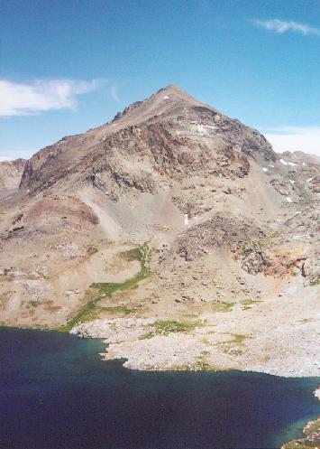 Mt. Goddard over Martha Lake
|
| After a long look over the absurdly steep ledge (so steep that after a few minutes I got spooked and had to move back!), it was time to return to camp. we retraced our steps down to Ambition Lake, where another route to Reinstein was available. The ankle reminded me that camp was the best option, so I reluctantly continued back to Bighorn Lake. From just above that lake the entire expanse of Blackcap Basin comes into view, with lakelets and tiny meadows strewn at the feet of its namesake peak. From the lake we took a new path toward Division Lake's outlet stream, pausing at the low divide for another wonderful view of Finger Peak to the south. Pearl Lake retured to view, and after crossing Division's stream and yet another low ridge we were back in camp. After slipping into more comfortable shoes, my first task was to find a flatter campsite and pitch the rainfly. The weather promised to be as good as the night before, but I wanted no mroe frost on my sleeping bag. After another fine dinner, we waited for the sunset (beautiful, but no alpenglow spectacle) and slept soundly in preparation for our two long days back to civilization. |
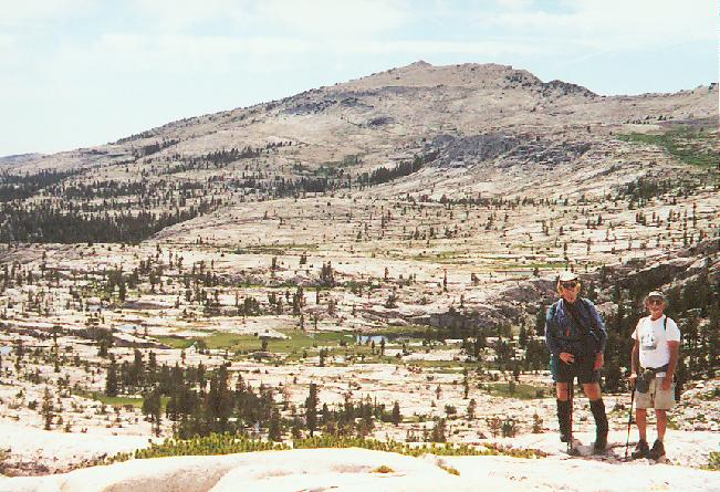 Blackcap Mtn, Frank, Del
|
|---|

 While still moist, the
area had dried considerably in the past five days, but flies and mosquitoes
still eagerly pursued us. With the distant peaks unavailable for photos, we
focused on closer subjects - wildflowers and the occasional butterfly lined the
path and provided intense splashes of color. We reached the gentle incline
leading toward Halfmoon Lake, only to find that my mind had deceived me: this
was NOT very gentle at all! As we ascended, views back toward peak 12323 and
northward toward Bench Valley opened up - even the highest portions of Goddard
could be seen above the ridges we had traversed the previous day.
While still moist, the
area had dried considerably in the past five days, but flies and mosquitoes
still eagerly pursued us. With the distant peaks unavailable for photos, we
focused on closer subjects - wildflowers and the occasional butterfly lined the
path and provided intense splashes of color. We reached the gentle incline
leading toward Halfmoon Lake, only to find that my mind had deceived me: this
was NOT very gentle at all! As we ascended, views back toward peak 12323 and
northward toward Bench Valley opened up - even the highest portions of Goddard
could be seen above the ridges we had traversed the previous day.At the junction below Halfmoon Lake we recharged our water-bottles and continued upward to Crown Pass. The views along the length of the Sierra began opening up near the crest, with dark, snow-streaked peaks of Ritter, Banner and southern Yosemite hovering at the edge of sight. Once over the pass, an equally vague impression of peaks south to the Kings-Kern Divide floated over the nearer peaks of the Monarch Divide. We worked our way down to Crown Lake among more wildflowers, shooting as we went. I was walking through a muddy patch when I noticed that the human footprints had some unshod company: I showed the others some rather large bear tracks, and we all turned from the flowers and took photos of the mud. Shortly thereafter we saw a couple of deer, our first animals larger than marmots we'd seen since day two.
We'd come quite a ways by now, and the route showed the path following the stream from Crown and Scepter lakes for a few miles. The actual path chose a higher, drier route, and when we finally encountered the stream we dropped our packs and searched for our last camp. Frank found several small sites above the trail, and we set up among the trees, ate quickly, and passed out in no time.
Day Nine and Out - the last day of our journey. I had an airline ticket for the next day, and
Del had another appointment in the Sierra the day after. Our empty bear
canisters also suggested that we move on! For the only time on the trip we
awoke to dry gear, so we were under way in short order. Most of the peaks were
invisible in the forest, so we moved at a good pace over Chuck Pass and down the
Woodchuck Creek valley. We expected to see people entering the wildlands this
day, yet secretly hoped that we would reach the trailhead without contact; that
would be 7˝ days without other human contact! We snacked under Finger Rock
just like on day one, the rock standing tall under dark-blue skies rather than
wreathed in cloud. 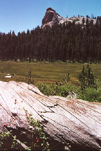 Several butterflies escorted us down this stretch of trail,
and we passed the final two marked junctions early in the afternoon. I
anticipated seeing the cars about 4:15, but an unmarked junction sent us steeply
downhill to an unmarked trailhead on a paved road! This spot could not be
reconciled on our maps, and after all our x-c daring we stood uncertainly on the
pavement. Del volunteered to continue onward, so Frank and I guarded the packs
as Del continued down the road. Soon he shouted back that a junction with 'our'
dirt road was in sight, and by 4PM he had picked us up in his van and dropped us
at the real trailhead. Greatly relieved, we moved on to Wishon Village for a
celebratory beer, then a short drive to Shaver Lake for pizza - our treat to Del
for his kindly act. After a fine dinner, we sent Del on his way, and the 2001
North Fork Kings Expedition was over.
Several butterflies escorted us down this stretch of trail,
and we passed the final two marked junctions early in the afternoon. I
anticipated seeing the cars about 4:15, but an unmarked junction sent us steeply
downhill to an unmarked trailhead on a paved road! This spot could not be
reconciled on our maps, and after all our x-c daring we stood uncertainly on the
pavement. Del volunteered to continue onward, so Frank and I guarded the packs
as Del continued down the road. Soon he shouted back that a junction with 'our'
dirt road was in sight, and by 4PM he had picked us up in his van and dropped us
at the real trailhead. Greatly relieved, we moved on to Wishon Village for a
celebratory beer, then a short drive to Shaver Lake for pizza - our treat to Del
for his kindly act. After a fine dinner, we sent Del on his way, and the 2001
North Fork Kings Expedition was over.
This was a trip that added plenty to my level of backpacking knowledge. It showed me
that a standalone tarp can handle three days of rain, whether I want it to or
not. It showed me that base-camp trips are a fun way to see diverse country,
that hiking partners can be found on the Internet, and that one can never
quite be sure that trailhead junctions are what (or where!) they seem to be.
I learned nothing but good things about west-side trailheads - they can be
even less crowded than the steep east-side entries, for example. While hiking
through a genuine forest was new to me in the Sierra, it wasn't all that bad
compared to the Oregon jungles that I usually fail to see through for views of
peaks and lakes. While the final route did not match up to the original plan,
I was not greatly disappointed; the rain had quite a lot to do with that, and
our improvised route showed nearly every bit of country that we'd planned to
see. Once the weather relented we had perfect weather, perfect solitude and
amazing views of unnamed peaks and seldom-seen lake basins. I hope to return
to that area and check out the adjacent basins in Bench Valley and upper
Goddard Creek some day.
[It must have been a great trip, since all these wonderful memories are reclaiming me over sixteen months later!]