|
|---|

Bloody Canyon to Yosemite
But oh, those rewards! The exquisite Camp Two along the Kuna Crest, looking straight across the canyon to Mts. Lyell and Maclure! The shocking beauty of Camp Three at the base of Banner Peak! The ungodly descent into the North Fork San Joaquin headwaters, and its rewards at Twin Island Lakes! Even the crowded but spectacular descent into Yosemite Valley at trip's end. As we noted before the trip: even though we may miss a few fine destinations, any route we take will be amazing and beautiful. And, of course, we were right. We were right a lot on this trip, with decisions that later would prove to be extremely foresighted in most cases. So nearly everything worked in our favor: our intuition served us well, our bodies and gear held up, the weather was most excellent, the route was truly spectacular, and the rewards and lessons learned will serve us well in the future. Especially the one about ambition tempered by reason, and making time to RELAX.
* Up Bloody Canyon to Mono Pass
* Across Kuna Crest to the Muir Trailą, presumably meeting it at Donohue Pass
* Cross to the NF San Joaquin above Thousand Island Lake via the 'Sierra High Route'˛
* Head north from Bench Valley into the Lyell Fork Merced drainage
* Reach trails again where the Isberg Pass trail crosses the Lyell Fork
* Descend to Yosemite Valley, with possible stops on top of Clouds Rest and/or Half Dome
ąusing RJ Secor's Sierra guidebook
˛using Steve Roper's High-Route guidebook
This truly ambitious route would require several days to cross trackless terrain, and from Thousand Island Lake to the Isberg trail would violate my 1999 vow to avoid consecutive days of x-c travel; I could only hope this violation would not impose too high a fine! We had eight days to perform this feat, possibly extending into day nine but with mighty resistance from Scott at the idea. Read on to see how our route and schedule fared!
|
|
|---|
Truly we were off - in less than a minute we crested a small hill and watched the trail descend sharply to Walker Lake. This suggested two things immediately: my message to Wally saying we started at the lake was inaccurate, and 2) my maps AND guidebooks were lying to me. If we're not starting at Sawmill Canyon (due to the gate), nor at Walker Lake, where exactly were we? And Larry was striding up a more appropriately-sloped (uphill) path, suggesting that it made more sense. In the confusion Larry was the most certain, so again we were off!
Ten minutes later we were WAY off: the fine-looking trail deserted us and we began bushwhacking across the slope in search of a way into Bloody Canyon, where the True Trail would presumably be found. We considered retreating, but it wasn't in our nature to give up without a struggle. So we struggled, crashing along on a slightly ascending traverse in search of a route between forest and cliff that would lead to the creek. By the end of our first hour we were exhausted, willow-whipped and thirsty, but we had worked our way across the creek and found the path patiently waiting for us. It was hardly an auspicious beginning, but after a bit of rest .. we were off!
The day was fine and hot, a bit more buggy than our liking (thanks in part to some fine aspen groves, which Larry pointed out are a good indicator-species for mosquitoes), but the path kept us on our way. We passed two pretty waterfalls - well, really steep slides to be more precise, but John Muir called them waterfalls back in the 1870s and NO one argues with him! - and we reached lower Sardine Lake late in the afternoon. With our early detour draining our strength and enthusiasm, we decided that this lake would make a fine camp.. assuming we could find a site. Larry wandered a bit and came back with news of good sites at the far end, so we staggered over and set up shop. A nice place, though again a bit buggy.
Day one ended on a disturbing note: my reliable white-gas stove refused to pump. It worked only reluctantly, creating its own pressure after a few iminutes; most certainly a bad way to start a long trip! I opened the pump chamber and discovered that the rubber gasket had pinched and deformed; I put it back in its place, and it worked much better.. for one day. It was sick again on later days - the gasket looked weak where it had been pinched - but the stove worked acceptably. (One of the first stops after the trip was at a store that sold replacement Coleman pump parts.) I decided to forego the tarp and sleep under the stars (well, trees and stars) with a bug-net over my face; it worked except for the droning bugs, which drove me slightly mad and made me sit up several times swatting the air. After several swings I would overheat in my cool-weather bag, which probably attracted still more bugs. Inevitably I slept.
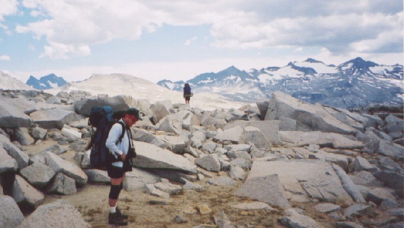
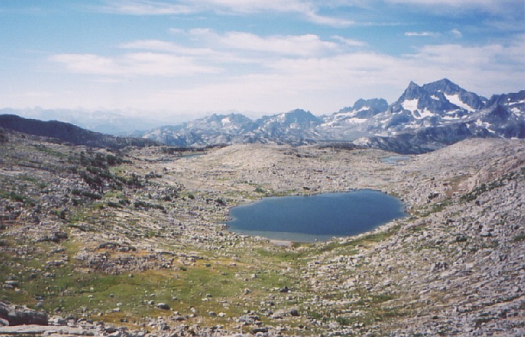
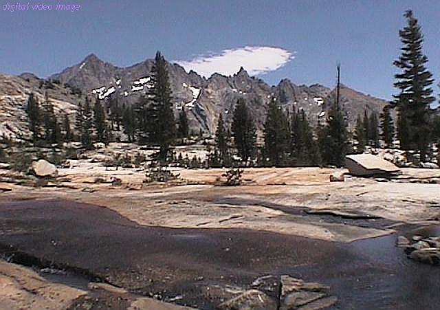
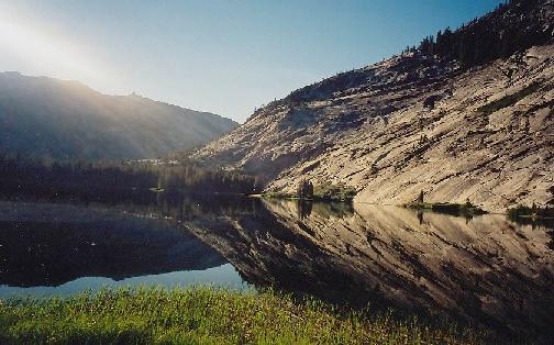
 It wasn't long until the pass came into view, along with an interesting geology lesson. The area of Bloody Canyon is probably not named after the mosquitoes but for the red metamorphic rock that tints the area (with a bit of dark grey and gold). This area is clearly not granite! Yet, looming behind Mono Pass stood the Kuna Crest, appearing bright white in contrast to the rusty foreground. The granite more typical of my Sierra jaunts awaited us! We reached the pass, thereby entering Yosemite NP: the classic cutout-metal sign announcing the pass was a clear indication we were there. We turned south and approached the mining cabins (a group of day-hikers was ahead of us, our first sight of humanity since highway 395), but then I realized that the Parker Pass trail shouldn't go that way. We struck off in search of the correct trail and found it rather quickly. Along the way I was startled by a large furry body with a rabbit's ears attached - easily the biggest jackrabbit I had ever seen! It bounded toward Larry so I shouted: "Larry! Jackrabbit!" He later told me that he also would not have expected something that big to be a rabbit, and that Scott suspected it to be a coyote (he was too far away to see the giveaway ears or cottontail). After less than a mile we were off the path again, heading for the stream that connected Spillway and Helen lakes. We reached the swiftly-flowing stream and headed uphill to Helen Lake, where our paper guide suggested a path to the right of the lake. We skirted the south side of the lake before veering right to the base of the final climb, when Larry (further to our right) suggested his path had minimal appeal. Scott and I went a bit left, meandered gently over large and rickety talus, and gratefully reached the top of the Kuna Crest. Somewhere in here Larry decided that we resembled (phonetically, at least) a magical charm that wards off evil - and we christened ourselves as the Talus-Men. Apparently we did ward off sufficient evil, since we completed the trip with only minor damage. We were nearly 12000 feet up at this pass and at the highest point of our trip, though we didn't know it then. Despite his route Larry reached the top just ahead of us, and we sat back and savored the hard-earned view.
And what a tremendous view!
 Our climb had revealed the Sierra crest behind us, including Mt. Dana and part of the Yosemite road through Dana Meadows, but the million-dollar view was now to our southwest. Mts. Lyell and Maclure proudly showed off their high-quality glaciers and led a parade of peaks that lowered only slightly before rising again as the Cathedral Range. In that low gap was a granite dome that looked suspiciously like the highest part of Half Dome! Further left of Lyell, through a low gap east of Donohue Peak, we had our first glimpse of the Banner/Ritter massif which so dominates the area south of Donohue Pass along the Muir Trail. We'd be seeing it up close soon enough, but this day belonged to Lyell and Maclure.
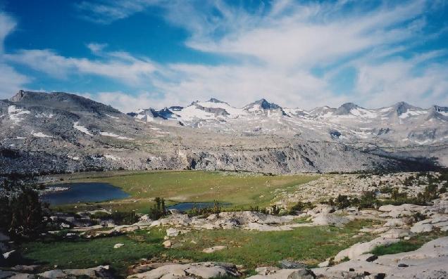
After dropping and contouring south we began seeking a camp with decent water. We found an excellent spot with a dying stream (decent water but little flow), dropped our packs and looked over the next ridge for better water. Since the next basin showed little water and more exposure, we returned to our packs and sought a good camp. We had several excellent choices, and settled on a spot somewhat elevated and surrounded by monstrous granite blocks. Clouds now drifted overhead, but two claps of distant thunder was all the trouble they could muster. We cleaned up and ate, still marveling at the views, and then were treated to a fantastic sunset. Larry and I scrambled over rocks in search of yet another angle as the clouds turned to gold, then a cool rose as alpenglow settled over the snowy peaks. This was a memorable day - and it was only day two!
 We decided to take the (apparently) more direct way south and angled toward Lost
Lakes Pass, crossing a perfect Sierra landscape of water, flowers, small
whitebark pines and a stunning backdrop (Lyell &c) beneath a wispy
cirrus-streaked sky. The left-side pass had a snowfield that Larry and Scott
took to gratefully, while I steered toward the more westerly, snow-free gap.
The view was impressive, reaching deep into the central Sierra to the south
(including my old friend Mt. Goddard which I had seen up close for three
consecutive years), while Banner Peak and Mt. Ritter punctured the skyline at
close range. I navigated easy class-two ledges for about fifteen minutes before
rejoining the other two for a brief break.
We decided to take the (apparently) more direct way south and angled toward Lost
Lakes Pass, crossing a perfect Sierra landscape of water, flowers, small
whitebark pines and a stunning backdrop (Lyell &c) beneath a wispy
cirrus-streaked sky. The left-side pass had a snowfield that Larry and Scott
took to gratefully, while I steered toward the more westerly, snow-free gap.
The view was impressive, reaching deep into the central Sierra to the south
(including my old friend Mt. Goddard which I had seen up close for three
consecutive years), while Banner Peak and Mt. Ritter punctured the skyline at
close range. I navigated easy class-two ledges for about fifteen minutes before
rejoining the other two for a brief break.
 The way down to the Lost Lakes was simple enough, and this stretch of land was
as impressive as the other side had been. Then we reached the outlet of the
lower lake and pondered our future.
The way down to the Lost Lakes was simple enough, and this stretch of land was
as impressive as the other side had been. Then we reached the outlet of the
lower lake and pondered our future.
It didn't look good. We were staring down sheer granite slabs inclined at
something close to 40 degrees, with minimal handholds and few cracks. After a
couple hundred feet the going would get easy again, but that was irrelevant for
the next twenty minutes! We pulled out maps and plotted our way to the Muir
Trail, but our focus was still much closer than those three miles. We slithered
gently downward, then gratefully followed the creek as it led us back toward
genuine trails. After a good while, though, we met nothing, and pulling out the
maps we noted with dismay that our creek was veering south to hit Waugh Lake and
the Rush Creek trail - and so were we! Rather than get greedy, we accepted this
alternate route and worked our way downhill, the reservoir now visible through
the trees. We traversed one particularly nasty 30-foot stretch (needlessly, as
it turned out) and reached the trail. Relieved that we no longer had to think
about the route, we headed west and encountered a group of men and dogs going
our way. We soon reached the John Muir Trail and took a break, letting them
take the lead toward Island Pass. The distance passed swiftly (while we looked
back toward the Lost Lakes and wondered "did we really do that??"), and soon we
were passing through a gorgeous scene of tarns and wildflowers. Suddenly we
were at the pass - one final tarn framing the Banner-Ritter group in all its
glory! We shot the scene and relaxed, preparing ourselves for the long stretch
of off-trail travel that awaited us.
 The pass at Lake Catherine was visible from here, and while it didn't look very
intimidating after what we had already done it was clearly no cakewalk (and
didn't cake sound good right about now?). We began again and soon left the
trail, seeking good water and a fine perch from which to attack the pass early
the next day. We ended up above Thousand Island Lake near its twin inlet
streams, and a bit of searching found enough space for small tents near a
slow-moving stretch of creek. The sun was nearly behind the cliffs of Mt.
Davis, and while the others set up tents I did a quick jump in the creek, giving
the sun sufficient time to dry and warm me. I again chose to skip the shelter
for the night, and just after dark I remembered the bug-net; when I returned for
it I saw Larry setting up his camera, shooting the Moon as it neared Banner Peak
(a magnificent tower from our camp). I grabbed my camera and got off a quick
shot before retreating to bed for a great night's sleep, bugged by far less bugs
than the first night.
The pass at Lake Catherine was visible from here, and while it didn't look very
intimidating after what we had already done it was clearly no cakewalk (and
didn't cake sound good right about now?). We began again and soon left the
trail, seeking good water and a fine perch from which to attack the pass early
the next day. We ended up above Thousand Island Lake near its twin inlet
streams, and a bit of searching found enough space for small tents near a
slow-moving stretch of creek. The sun was nearly behind the cliffs of Mt.
Davis, and while the others set up tents I did a quick jump in the creek, giving
the sun sufficient time to dry and warm me. I again chose to skip the shelter
for the night, and just after dark I remembered the bug-net; when I returned for
it I saw Larry setting up his camera, shooting the Moon as it neared Banner Peak
(a magnificent tower from our camp). I grabbed my camera and got off a quick
shot before retreating to bed for a great night's sleep, bugged by far less bugs
than the first night.
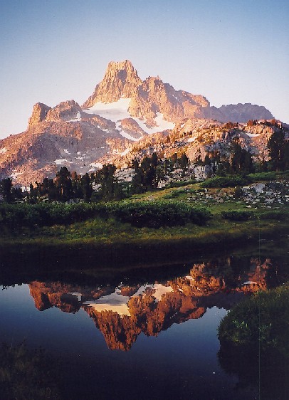 A glorious sunrise combination - utterly clear skies, Mt. Banner within shouting
distance, a slow unruffled creek for reflections, and a Thousand Islands in
silhouette - prompted Larry and I to rise early. Since we were going to bed
before 9PM, a 5:30 sunrise didn't hurt much, and this one would have been worth
an hour's sleep any time! The mornings were not cold by any means - I could not
see my breath on this or any other morning - and as the sun rose we swiftly went
into shorts and sunscreen despite the clock. After breakfast we were yet again
off, following the bouncing stream uphill to its snowy source. The snowfield
near the top was split in two, and I had veered left in anticipation of our
ascent. When Larry and Scott went right and ascended the other snowfield, I was
alone for twenty minutes. Other than one swift 'post-hole' drop in the snow (my
left leg sank in to above my knee-brace) the way was smooth, and I reached the
final ascent to the pass ahead of the other two. I waited as Larry and then
Scott came near, then crossed into the North Fork San Joaquin drainage.
A glorious sunrise combination - utterly clear skies, Mt. Banner within shouting
distance, a slow unruffled creek for reflections, and a Thousand Islands in
silhouette - prompted Larry and I to rise early. Since we were going to bed
before 9PM, a 5:30 sunrise didn't hurt much, and this one would have been worth
an hour's sleep any time! The mornings were not cold by any means - I could not
see my breath on this or any other morning - and as the sun rose we swiftly went
into shorts and sunscreen despite the clock. After breakfast we were yet again
off, following the bouncing stream uphill to its snowy source. The snowfield
near the top was split in two, and I had veered left in anticipation of our
ascent. When Larry and Scott went right and ascended the other snowfield, I was
alone for twenty minutes. Other than one swift 'post-hole' drop in the snow (my
left leg sank in to above my knee-brace) the way was smooth, and I reached the
final ascent to the pass ahead of the other two. I waited as Larry and then
Scott came near, then crossed into the North Fork San Joaquin drainage.
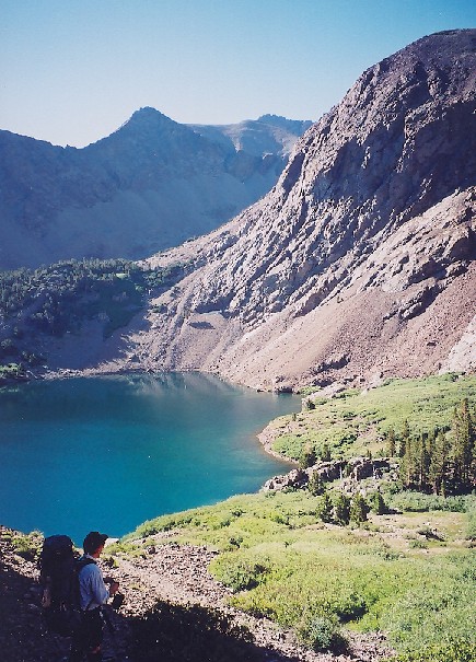
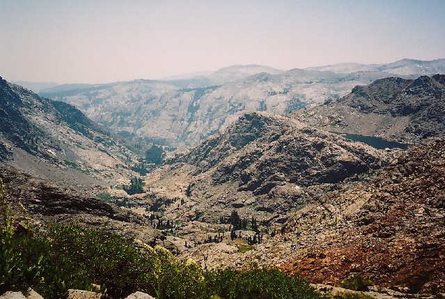
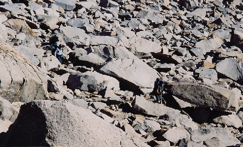
A tremendous and starkly wonderful landscape confronts you here, and on a clear
day you won't forget it any time soon. Lake Catherine fills the granite bowl
below, a deep indigo color that makes Oregon's Crater Lake seem merely a pretty
blue.
 A slash of ice and snow descends from the gap between Banner Peak and Mt.
Ritter, making the summits accessible in theory but not to me. The wind was, to
put it mildly, a bit brisk - so we rested and took photos while waiting for the
strength to tackle the next leg. Two day-hikers met us at the pass, intent on
climbing high on Banner Peak; we wished them well and saw them later as we
traversed Catherine's talus shoreline. A small lower lake put a short cliff or
two in our way, but we passed them soon enough and found ourselves on the brink.
The guidebook mentioned the view from here, but as it was in the Wind River
Range with the first sight of Mt. Hooker, it has to be seen to be believed.
Words and pictures fail as one tries to capture the disheartening view of a
vertical wilderness such as this, and the sight of a small piece of one of the
Rock Island Lakes was not in any way reassuring. However, someone made a strong
claim that a way can be found, so with their reassurance supporting our own we
sought the way, chanting our mantra "whenever in doubt, go right" as we sought
enlightenment at every cliff-face. Every fifteen minutes or so we reached one
of these cliffs, and with sinking stomach we peered over the edge. Sure enough,
if we made a descending traverse to the right we could go another ten minutes to
.. another cliff-face. Spooky though it was, it worked: we soon crossed a
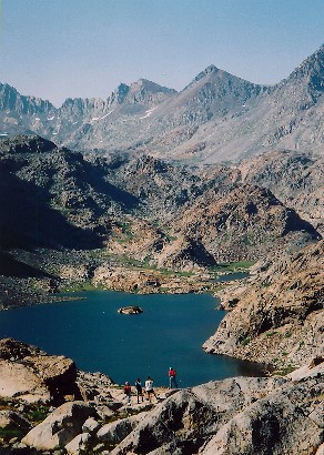
creek, passed through a gap near some reddish cliffs (mentioned in the guide),
and .. another cliff-face. Only a few left, though, and we were at the main
flow of the North Fork as it reached the northern Twin Island Lake. Oh, did I
say "we"? Actually I lost the other two and reached there first; I must have
descended by a different route while they waited for me elsewhere. After an
anxious few minutes I reached for the whistle, but then I saw Scott waving from
higher up the hill. Relieved and a bit annoyed, I took a nice break waiting for
them, only to lose them again when I had to go back to the resting-place for my
camera (turned out it was attached to my pack but I couldn't see it until I
began removing the pack in search of it). We met again at a wondrous spot, a
small cascade mere feet above the level of the lake; we took our sweet time
here, drinking our fill and resting in the mist from the short falls. Larry and
Scott soaked their feet, but since we were about to cross that same piece of
North Fork water below the lake I chose to wait for that moment to provide
relief to my feet. We wandered carefully along the eastern shore until we hit
the stream, swapped boots for water gear, and just as carefully crossed the
stream. Larry's walk kept him at calf level or below, while Scott and I were
closer to knee-height at midstream. After swapping back into boots, we
clambered upslope to the higher lake, the one we had seen impossibly reposed
from the stream below Lake Catherine. We reached it swiftly and rested some
more - this had been an amazingly hard day for the few miles we had traveled!
A slash of ice and snow descends from the gap between Banner Peak and Mt.
Ritter, making the summits accessible in theory but not to me. The wind was, to
put it mildly, a bit brisk - so we rested and took photos while waiting for the
strength to tackle the next leg. Two day-hikers met us at the pass, intent on
climbing high on Banner Peak; we wished them well and saw them later as we
traversed Catherine's talus shoreline. A small lower lake put a short cliff or
two in our way, but we passed them soon enough and found ourselves on the brink.
The guidebook mentioned the view from here, but as it was in the Wind River
Range with the first sight of Mt. Hooker, it has to be seen to be believed.
Words and pictures fail as one tries to capture the disheartening view of a
vertical wilderness such as this, and the sight of a small piece of one of the
Rock Island Lakes was not in any way reassuring. However, someone made a strong
claim that a way can be found, so with their reassurance supporting our own we
sought the way, chanting our mantra "whenever in doubt, go right" as we sought
enlightenment at every cliff-face. Every fifteen minutes or so we reached one
of these cliffs, and with sinking stomach we peered over the edge. Sure enough,
if we made a descending traverse to the right we could go another ten minutes to
.. another cliff-face. Spooky though it was, it worked: we soon crossed a
creek, passed through a gap near some reddish cliffs (mentioned in the guide),
and .. another cliff-face. Only a few left, though, and we were at the main
flow of the North Fork as it reached the northern Twin Island Lake. Oh, did I
say "we"? Actually I lost the other two and reached there first; I must have
descended by a different route while they waited for me elsewhere. After an
anxious few minutes I reached for the whistle, but then I saw Scott waving from
higher up the hill. Relieved and a bit annoyed, I took a nice break waiting for
them, only to lose them again when I had to go back to the resting-place for my
camera (turned out it was attached to my pack but I couldn't see it until I
began removing the pack in search of it). We met again at a wondrous spot, a
small cascade mere feet above the level of the lake; we took our sweet time
here, drinking our fill and resting in the mist from the short falls. Larry and
Scott soaked their feet, but since we were about to cross that same piece of
North Fork water below the lake I chose to wait for that moment to provide
relief to my feet. We wandered carefully along the eastern shore until we hit
the stream, swapped boots for water gear, and just as carefully crossed the
stream. Larry's walk kept him at calf level or below, while Scott and I were
closer to knee-height at midstream. After swapping back into boots, we
clambered upslope to the higher lake, the one we had seen impossibly reposed
from the stream below Lake Catherine. We reached it swiftly and rested some
more - this had been an amazingly hard day for the few miles we had traveled!
Larry and I had lost our millions; now it was Scott's turn to lose. While
setting up his tent, a gust of wind sent it airborne as he was reaching for the
stakes. With a single high bounce off its springy fiberglass poles, it made
straight for the lake! Larry had planned to take a quick dip in the near
future, so this event accelerated his plans; he rushed to the lake, stripped and
jumped, while I passed over some short cliffs that stood near where the
now-sinking tent was drifting. Larry paddled the tent over to me, then unzipped
the door so we could lighten its load before handing it to the still
shell-shocked Scott. Within an hour his tent was not only dry again but cleaner
than it had been in quite some time, while Larry rested on sunny granite slabs
to get warm. I again chose to sleep sans shelter, and this night the
bugs were quite respectful, allowing me a good night of sleep. Exhaustion was
most likely another contributing factor.
 This would be our last view of Mt. Ritter and the
Minarets, and much of the central Sierra (the Silver Divide and points south)
showed up for a curtain call as well. On the far side, the Clark Range now
appeared in silhouette against the lowering sun. A beautiful view, but no place
to rest for long!
This would be our last view of Mt. Ritter and the
Minarets, and much of the central Sierra (the Silver Divide and points south)
showed up for a curtain call as well. On the far side, the Clark Range now
appeared in silhouette against the lowering sun. A beautiful view, but no place
to rest for long!
Aside from the cold wind, we had another steep slope to descend before reaching
camp, so after a short break and more photos we marched wearily down. The slope
at first looked good on the left, but after ten minutes the right began to look
much better; as Larry and Scott worked their way down the steepest stretch I
doubled back and came further right. We met at the highest lake and continued
down toward several inviting lakes in a rather barren landscape. We really
needed to find a camp pretty soon, yet camping by a treeless lake did not hold
much appeal, so we veered north toward where Foerster Creek should be. Soon we
reached a couple of dry creek-beds, but the next valley held a small tarn and
moving water- not a great flow, but good water nonetheless. We didn't search
long before settling on a nice spot, and we hardly finished our dinner before
the sun set.
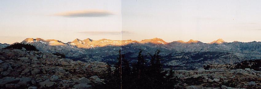 Another glorious sunrise revealed the Clark Range in all its multicolored glory,
and a few lenticular clouds - the 'Sierra Wave' - formed and dispersed as the
sun advanced. Even with the trail so close at hand, we steered north instead of
west: at the very least, we would get a look at the Lyell Fork from high above
its southern rim! After all, what's another hour of off-trail travel to the
Talus-Men? We reached the precipice and found a lovely view below us, and we
explored the valley with our eyes since our feet would not have the chance.
Perhaps another time ...
Another glorious sunrise revealed the Clark Range in all its multicolored glory,
and a few lenticular clouds - the 'Sierra Wave' - formed and dispersed as the
sun advanced. Even with the trail so close at hand, we steered north instead of
west: at the very least, we would get a look at the Lyell Fork from high above
its southern rim! After all, what's another hour of off-trail travel to the
Talus-Men? We reached the precipice and found a lovely view below us, and we
explored the valley with our eyes since our feet would not have the chance.
Perhaps another time ...
We retreated from the edge and now moved west, and in less than a half-hour we were on trail again! Not since Island Pass had we traveled on a genuine trail, and we were greatly relieved that we could take our minds off the near horizon and concentrate merely on keeping our feet on the path. At the Lyell Fork we found bugs and a swift stream, so we de-booted and crossed in our water shoes before moving on. Several huge junipers gripped the granite firmly along the path, a most impressive sight. Soon thereafter we passed what several guidebooks refer to as one of the Sierra's best camps: a splashing waterfall, level ground, and picture-window views of the entire Clark Range. We continued north with a vague plan of camping near the junction of the Isberg and Vogelsang trails, but somewhere in here that old quote came back to us. Scott suggested that, with a bit more of a push, we could in fact be at the car by the following afternoon. I was pooped but willing, and Larry agreed that we had seen far more than our share of beauty; we therefore advanced our schedule and aimed for Merced Lake, which would leave just over 14 miles of work for day seven. This would cut Half Dome from the schedule, but we had been on several viewpoints just as awesome, and without the crowds or cables. [The fact that these two final days would be harder than if we had camped in the Lyell Fork valley was conveniently ignored at the time..]
 We dropped down to the junction at Lewis Creek, only to be confronted with
several new sensations. Among the first was a string of horses, each with a
helmeted visitor bouncing along between guides. I had expected that this
junction would effectively mark the end of our isolation, yet this was still a
surprise! The next new sensation was even worse: cobblestones? For reasons
that don't seem to appeal to horses OR hikers, the National Park Service had
employed a great many people in the construction of trails that forced a slow
pace on everyone - just what we did NOT need for our sprint to the car! We
worked our way down to the Merced, then camped at the first available site as
darkness tried to catch us walking yet again. A short way past the ranger
station we found a huge and unused camp area, which we promptly made use of.
Our plans were to be awake and ready to move by 6AM, so we turned in rapidly in
order to recharge our weak batteries for the final push. Before turning in I
wandered back to the ranger station for news. We had seen smoke further down
the valley, and we needed to be sure that our route wasn't blocked. I returned
with two important pieces of news: the path was clear, and beer was still being
produced (the ranger station had a 12-pack of Sierra Nevada Pale Ale on its
table). Since we had stopped a mile short of our goal, we had fifteen miles to
go; the ale news put Larry in the proper frame of mind! A good night's rest
would recharge us for the last long haul.
We dropped down to the junction at Lewis Creek, only to be confronted with
several new sensations. Among the first was a string of horses, each with a
helmeted visitor bouncing along between guides. I had expected that this
junction would effectively mark the end of our isolation, yet this was still a
surprise! The next new sensation was even worse: cobblestones? For reasons
that don't seem to appeal to horses OR hikers, the National Park Service had
employed a great many people in the construction of trails that forced a slow
pace on everyone - just what we did NOT need for our sprint to the car! We
worked our way down to the Merced, then camped at the first available site as
darkness tried to catch us walking yet again. A short way past the ranger
station we found a huge and unused camp area, which we promptly made use of.
Our plans were to be awake and ready to move by 6AM, so we turned in rapidly in
order to recharge our weak batteries for the final push. Before turning in I
wandered back to the ranger station for news. We had seen smoke further down
the valley, and we needed to be sure that our route wasn't blocked. I returned
with two important pieces of news: the path was clear, and beer was still being
produced (the ranger station had a 12-pack of Sierra Nevada Pale Ale on its
table). Since we had stopped a mile short of our goal, we had fifteen miles to
go; the ale news put Larry in the proper frame of mind! A good night's rest
would recharge us for the last long haul.
NIGHT SIX So much for recharging! At 2AM Larry found himself face to face with a good-sized black bear; his shout sent it wandering in a new direction (toward MY shelter!). I woke up, retrieved my whistle and lamp, and tooted him on his way - even though I didn't actually see the bear as I was blinded by Larry's light. Larry suggested that I grab his walking-stick for his defense in case of a closer encounter, so I swung my lamp to our gear to find his stick. Either the same bear or another one was exploring there, so I whistled and flashed my light until he moved toward the river (which he probably did regardless of my actions). All our food was securely stuffed in bear canisters, but any damage to our gear would make life on the last day pretty miserable. At last we saw no trace of the bear(s), so we tried to relax and get back to sleep. Needless to say, it took a while!
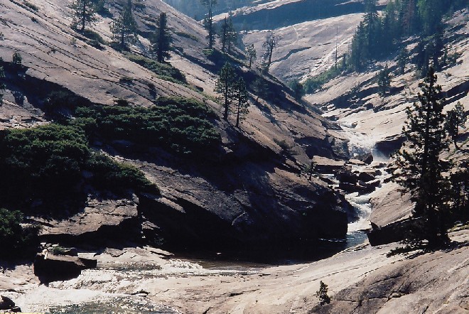
 The stream was just as beautiful below the lake, and we soon met
the junction at Echo Valley. Since we no longer planned to capture either
Clouds Rest or Half Dome, we turned left and followed the Merced past Bunnell
Point and its sliding cascade, and finally to Little Yosemite and another chunk
of the Muir Trail, which we would follow the rest of the way. The smoke was
still pretty thick, but not getting much worse. We were now meeting more and
more people, mostly with small rucksacks or even less; none seemed willing to
trade me packs despite the clear economic advantage of my gear! Soon enough we
were at the Mist Trail junction, passing a group of over a dozen teens and two
harried adults. It seemed that well over half the teens were out of water, many
for quite some time; the adult refused my offer of water from my bottle and
began a lecture that I'm sure they had heard before.
The stream was just as beautiful below the lake, and we soon met
the junction at Echo Valley. Since we no longer planned to capture either
Clouds Rest or Half Dome, we turned left and followed the Merced past Bunnell
Point and its sliding cascade, and finally to Little Yosemite and another chunk
of the Muir Trail, which we would follow the rest of the way. The smoke was
still pretty thick, but not getting much worse. We were now meeting more and
more people, mostly with small rucksacks or even less; none seemed willing to
trade me packs despite the clear economic advantage of my gear! Soon enough we
were at the Mist Trail junction, passing a group of over a dozen teens and two
harried adults. It seemed that well over half the teens were out of water, many
for quite some time; the adult refused my offer of water from my bottle and
began a lecture that I'm sure they had heard before.
 We moved on to the river just above the falls, where we took a break and
observed the fire that was burning in the hanging valley between Nevada Falls
and Half Dome. As it turned out, the Half Dome trail was closed due to the
fire; had we tried to reach the summit we would have lost plenty of time and
valuable energy!
We moved on to the river just above the falls, where we took a break and
observed the fire that was burning in the hanging valley between Nevada Falls
and Half Dome. As it turned out, the Half Dome trail was closed due to the
fire; had we tried to reach the summit we would have lost plenty of time and
valuable energy!
The final three miles now awaited our footsteps! We strode / staggered down the steep trail, encountering still more people whose accents betrayed a wide range of foreign visitors. Some of the conversations I had were quite interesting, most especially the one where the man offered to shoot me to ease my 'broken leg' (I was wearing a knee-brace, as I had pretty much the entire trip). I asked for a last beer before being shot, and he pretended to acquiesce before laughing and passing me by. As has happened so often in the past, Scott began to accelerate as the finish line drew near; I let him pass and wandered down with Larry, whose knee was troubling him on the descent. We reached a junction with no sign of Scott, or the Muir Trail: just a sign that cryptically read "foot traffic only". While that sounded promising it was decidedly unclear, and since I saw no sign on the other trail we chose to go that way. (Scott claims this trail was marked for stock; sure would have been nice to see that sign!) The trail was clearly leveling off, but of course the temperature was pretty warm down here, the lowest elevation we had visited since .. who knows, but it was long ago when we traveled by car! As we crossed a stream I asked Larry if he needed to stop for a bit. He pondered it a while before realizing that this proved he needed a break, so we broke for a while by the pretty stream. At last we hit pavement, and followed it into civilization!
As we came into a crowded area we could see Scott at the end of the other trail, shouldering his pack and mentally preparing to go back up to find us! We shouted until he turned around, and we were united again at last. A brief walk to the Happy Isles parking lot followed, where we happily found Scott's truck in plain sight (thanks again, Wally!). After a quick celebratory beer (Larry practically insisted it match the ranger's brew of choice, no complaints here) and a new shirt to replace my 1971 "go climb a rock" logo, we were off - this time on wheels. Scott called and canceled his reservation for the following night and booked himself into Bishop instead. We enjoyed the drive over Tioga Pass very much, looking back from Dana Meadows to our day-two territory, and by late afternoon we were at the Walker Lake trailhead. I noticed that an 'agriculture inspector' had examined my car, dressed in a bear costume: one huge pawprint and several smears were evident. Sure was glad I had rolled up that window! (Later inspection found a wet nose-print on three of the four front windows, and I wiped other paw-prints off when I cleaned the rear window.. they had been pretty thorough!)