The autumn 2002 Sierra journey was unique in so many ways, it might prove difficult to count them all. First off, it was October, and where I come from that's bundle-up-and-stay-indoors weather as the first storms return to the Pacific Northwest after a few months' absence. To be standing at 10000 feet in October, wearing a t-shirt and shorts, simply does not come to mind! Then there's the fact that I was truly alone in the wilderness, something I had contemplated but never seriously planned (not even this time!). Add to that the actual route I was following, which caught even me by surprise: a week before departure I did not even have this spot on my top-five list! As a hiker who was micro-managing trips a few short years ago, it was an amazing bit of improvisation. Here's the story of how I got to the Sequoia NP Tablelands in October 2002.
Preparation
Partners?
Re-Preparation
Therefore, just two days before leaving Portland, I had an entirely new plan and
possibly even a companion! Since part of that plan included visiting relatives,
and I had not contacted any of them during my mad scramble to schedule
vacation time, I now made a few calls. Sadly, the second weekend (Columbus Day)
looked like the best time to catch them all at home, and with the weather
forecast clearly favoring an earlier trip, it appeared that I again was about
to lose another hiking partner.
Calling what I did for three months 'preparation' is humorous in itself, but I
have to call all that work something. In part a second trip was forced
by a lack of time on the first 2002 trip to Yosemite in
July. My crowded schedule did not allow me to visit relatives in southern
California after that hike, so I promised several people that, if at all
possible, I would drop in later this year. My work schedule was messy in
September, but I was able to work in some free time around Columbus Day to
head south. In the back of my mind was the Sierra, aspen trees going gold, and a
few side-canyons that I could check out along the way; I mentally worked my way
along US 395, exploring each trailhead for a 3-day trip. I listed the
possibilities, prioritized them, and had a top-three list rather quickly.
I was also seeking people to accompany me on the trip. A co-worker had seen
my July photos and left me a note: can girls come? I offered her a spot on the
October trip, which she contemplated eagerly.. but her schedule would not
allow her the time so she reluctantly stayed home. An Internet companion was also a
good candidate, but once again the scheduling became unworkable. I began to
think about a solo trip and what that would be like. Its main appeal was
that, somewhere inside me, a little voice didn't think I could handle it.
"You're a fraud, only as good as the companions you hike with". All my trips since '99
had been quite challenging, with long cross-country stretches and plenty of
tough routes among granite cliffs and ragged peaks. I had always handled the
terrain well, picking routes as good as any and better than most - but could I
do it without someone else's feedback? Perhaps it was time to find out.
In the final week leading up to the trip, I reshuffeled my routes, partly
because I would be going it alone. My top choice was Dusy Basin, which would
hopefully be a bit less crowded than in the summer but still likely to have
people handy if needed. Since I had visited the area surrounding it, I had no
need to add it to a longer trip, so I could camp in the Basin, day-hike around
to see all its wonders, and head back out again. The backup routes were Convict
Creek and Big Pine Creek, both worthy destinations that did not require a week
to see.
Then the storm hit. With winter-storm warnings flying down to 6500 feet, I
began to doubt the wisdom of crossing a 12000-foot pass to camp at 11000 feet
less than a week after a foot of snowfall. I reshuffeled again, choosing
Convict Creek with its lower trailhead and campsites as my primary goal.
Then two more events changed my thinking. I contacted another potential
Internet hiker, who sounded interested in my plans but was better prepared for
the second of my two weekends; we agreed to meet as I traveled south to
discuss
our options. She was on the west side of the Sierra, but well-situated for me
to cross over to the east side for my primary routes. Event two was a narrative
on the Web from Charles Hayden, who had just completed a solo trip in the
Tablelands area of Sequoia National Park. This area was a first runner-up for
the 2001 trip, and that area had been on my short list since 1998. Suddenly all
became clear: I would stay on the west side on the southbound drive, then return
home up the east side!
Saturday was a typical Oregon autumn day: clouds, drizzle, mid-50s, me in a
long-sleeve fleece top & long pants. I left Portland around 10AM and headed
south. A long drive ended in Williams CA, temps in the 80s and no clouds in
sight. I was so overheated I jumped in their pool, noticing immediately that
nowhere was a 'heated' pool implied! The chilly water felt fine, though, and
I was better prepared to face a California autumn after that!
Sunday I traveled south to meet Kerry, and break the bad news about our hike plans. It was a great meeting despite the disappointment, and we made tentative plans for future trips as we learned a bit more about each other. Even as we spoke I mentioned my uncertainty about which route I would take the very next day, but I sold myself on staying with the Tablelands instead of crossing to Convict Creek. Energized by our conversation, I resumed my journey south, only to stumble one last time at a Yosemite Park exit. July's trip had run out of energy before we could visit the Clark Range; could I catch that area now? I pulled over to study my multitude of maps (I brought plenty for just such a decisional crisis as this!). The mileage looked a touch long for three-plus days, so yet again I headed south toward Sequoia. I could not believe I was so indecisive about this trip - in the past I was disturbed when I couldn't reach camp six on an eight day trip, and here I was playing for three whole days without a clue.. this clearly would not be an ordinary trip!
I finally reached the park(s), and despite my fascination with Kings Canyon (yet another old plan, this one to Granite Pass, was singing its siren song) I bore right to Sequoia's Lodgepole visitor center. I arrived barely in time to speak with the ranger, learn a few facts and buy some maps & a geology book before the shop closed. I grabbed a burger and some souveniers at the main store, wrote out a wilderness permit (wow, you can DO that in the autumn!!) and set up camp. This place was serious about their bears: each camp had its own metal box, several large spares were available, and a large board displayed how many cars were broken into in the last seven days (down to just two, but then again the camp was about 25 percent full..). I carefully cleaned out the car, recycling pop bottles and seeking out the dropped pretzels between the seats before turning in. The weather was perfect, I was feeling fine, and all was ready. I was even convinced that I finally knew where I was going: day one to Pear Lake, day two off-trail to the Elizabeth Pass trail, day three along the Elizabeth Pass and High Sierra trails, and out early on day four. A plan at last! It sure was strange to be turning in at 7PM, though - the loss of daylight would be another of those new experiences that this trip promised to be full of.
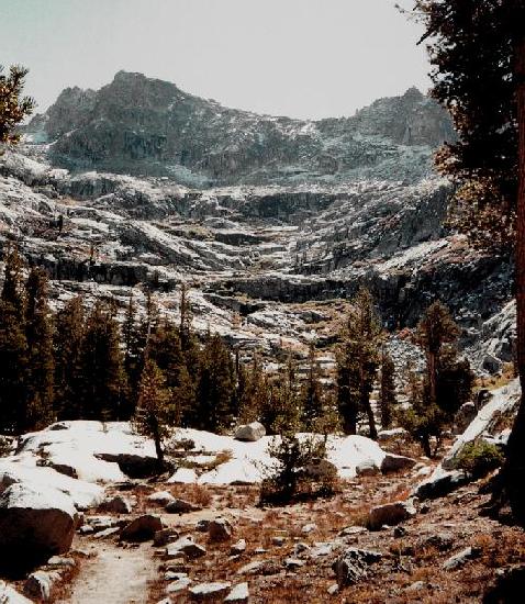
The views increased in splendor as I passed the view over Tokopah Valley and
reached the first lakes. The previous week's snow was still resting in every
crack on the north face of Alta Peak, making the scene even more special and
odd for a July-August veteran. I was still cruising in high gear, and when I
reached Pear Lake it was .. lunchtime? Two guys were at the lake, one of whom
had just decended Alta Peak. I had explored the slope to the northwest and
thought it looked pretty straightforward, so instead of setting up camp I set
up my stove. I ate my freeze-dried dinner for lunch instead while sitting
shirtless in the sun, searching the topo map for alternate routes while
basking in the sheer unreality of the scene. An Oregonian, shirtless in October,
at 9500 feet - how can this be?!?
In keeping with my new freewheeling attitude, I decided to abandon the
northwest-slope route and follow Pear Lake's inlet stream instead, similar to
where the Alta Peak climber had come down. I could not quite reach the inlet
due to an impressive cliff, so I scrambled up the ridge to a small gap that led
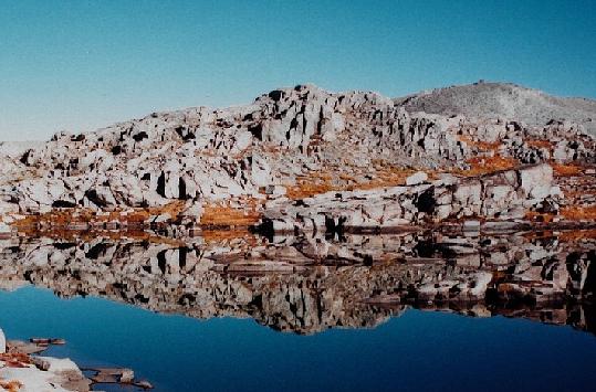
to views of several small lakes. I was now aiming for a group of three lakes at
10800 feet for my first camp, and with perfect weather and a good map I was
navigating comfortably (though without compass). More unreality was confronting
me in these high valleys of golden grass: not a single wildflower in sight,
hardly anything green at all! I passed through another small gap, and before me
were the three lakes. It was 3:15, and while I still had some spare energy I
recognized that overworking on day one could bring big penalties later. I set
myself up on a nice bench near the southern lake, presuming that I would head
due east to the ridgeline the next morning before following it north. [In
several instances on this trip I recorded my prospective route with the video
camera, then set out by another way.. it makes for fun viewing!]
Shortly before sunset I ascended a small knob by the northern lake, and saw
the route NE from there was even easier than plan 'A' (I also saw that this lake
was much prettier than mine, though not enough to move camp!). The sunset was
colorful, thanks in part to the perpetual haze in the Central Valley. Soon
after I watched the crescent Moon and Venus pop into view in the southwest. I
had packed for extreme cold on this trip and was ready to sit out for a while:
dressed in my union-suit undies, fleece shirt (incredibly soft & comfy!), down
vest and boots, gloves and balaclava. I watched the stars come out. It's always
fun to see the difference in the sky from Portland to central California, noting
the lower position of the North Star and how Vega now passes just north of
vertical and not south, and how Sagittarius and Scorpius ride much higher above
the horizon than at home. When the chill finally began to reach me I slipped
into my new 1-person tent (pitched without rainfly throughout the trip) and my
warm down bag. Once my feet were warm I was perfectly snug through the night.
I did feel an altitude headache descend upon me during the night, thus removing
the superhuman scenario for my day's energy.
If any hiking partner were to ask my response to a planned day-one
hike of 7.5 miles and 3400 feet of elevation gain, I guarantee than 'nodding my
head and doing it' would not be among my answers - yet that's just what I did on
this trip. Amazing!
DAY TWO
DAY THREE
I lost that beautiful trail for a while where the trail crosses Lone Pine Creek
and a talus fieldsimultaneously; once out of the talus, I found it again further
uphill. Thelower elevation meant the sun was even more effective now, and I was
plenty hot in the shadeless river valley. Soon I
reached the High Sierra Trail, crossed the creek once more, and ascended into
shade, though at a steep angle. For the next few miles I could have either cool
shade or gentle grade, but never both at once. I was still unclear about my
route (surprise?), thinking now that the climb over shadeless Panther Gap would
be less appealing than the slightly longer Wolverton Cutoff trail - plus, the
latter route passed directly through a Sequoia grove, which would be worth
seeing. Another problem was my recording supplies: my 35mm camera was getting
low on film, while my video camera was low on battery. If I saw too much
scenery, I might be unable to record it! Nevertheless, I mentally prepped
myself for still more miles, so that I could reach the car by noon on the longer
trail.
Just before Bearpaw Meadow, I saw something I had not seen in two days: a human
being! He was on his way to Tamarack Lake, and I asked him about potential
camps along the HST. He noted that some spots did not have metal bear-boxes and
that I should choose a site carefully. With that in mind I continued past the
skeleton-cabins that were recently the High Sierra Camp, and the padlocked
ranger cabin at Bearpaw Meadow. I was aiming now for some place to camp past
the Panther Gap junction, though I was uncertain if any of the branches of
Panther Creek had secure campsites. My feet were feeling plenty raw by now, and
the best news was the thickening cloud layer that kept me shady the rest of the
day. I soon remembered that I had skimped on lunch, so I dropped my pack near
Mehrten Creek to pull out some energy bars. I heard people shouting nearby
about camps and fire-rings but never saw any one. Limping onward with somewhat
renewed energy, I reached the Panther Creek drainage but found only a few active
streams, none with camps. The last branch looked promising on the map, sitting
near the Wolverton Cutoff junction, and at 5:15 I was rewarded with a good flow
of water and a minimal camp. Just before removing my pack I noticed a faint
tread heading further uphill, where I found a much better site that included a
fire-pit. I did not have the strength for a fire that night, but welcomed the
sheltered spot that was only 30 yards from a decently noisy waterfall. Since I
planned on a stove-free breakfast, I ate a fine Teriyaki Chicken dinner, then
prepared everything for a quick exit the next morning. The song of the water
meshed with my exhaustion from the long day (over a dozen miles), and I slept well.
DAY FOUR
DAY ONE
After emptying my personal bear-box and repacking my pack, I drove from
Lodgepole to Wolverton, a very short trip. An older woman was just perparing
to hit the trail, and about four cars sat in the huge lot. I again placed my
travel food in a bear box (including a prized beer for celebrating the trip's
end), laced up my boots, and hit the trail.
 In only 45 minutes I reached a junction at 1.8 miles - could my pace
really be that good? Perhaps my July trip's extra red-blood cells were still
in place? Either that or I had become superhuman (or wired on adrenaline).
In only 45 minutes I reached a junction at 1.8 miles - could my pace
really be that good? Perhaps my July trip's extra red-blood cells were still
in place? Either that or I had become superhuman (or wired on adrenaline).
I awakened to the usual Sierra morning: clear and crisp. With great interest I
explored the scene to determine how cold the night had been: my surprising guess
was about 30�. My water bucket had NO ice on it anywhere, but my nylon
groundsheet had patches of frost that took a while to dry in the late-rising
sun. I figure that it takes me about an hour from sunrise to begin hiking,
given time to eat, repack and wait for moisture to burn off my sleeping gear.
Since I was behind a low rise, the sun didn't reach me until about 7:45, so
just before nine o'clock I was underway.
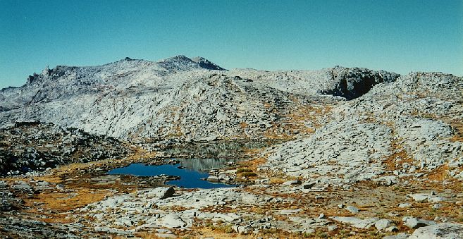
 I headed north to the pretty lake, then NE to the ridgetop, where
I was greeted by a stunning view of the Great Western Divide. As I scanned the
tremendous view it became clear to me that I was in part looking past the
Divide, as the tallest peak could be none other than the Black Kaweah! An
amazingly tall and ragged piece of rock, it towered over the towers of Mt.
Stewart, Eagle Scout Peak and the rest, silhouetted in the morning light.
Below me was a small lake below the cliffs leading south to Moose Lake, but it was
not in view from here. I worked my way north, finally getting to look over the
precipice to Table Meadow (part of my original route to reach this area, before
I reached Pear Lake). I worked my way past a few other small lakes before
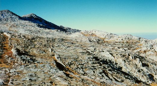
remembering that north was not my direction of choice - so I took a sharp
right and contoured at something near 10800 feet, heading inevitably toward
the pass between Buck Creek Canyon and the Elizabeth Pass trail. [This was
again a last-minute decision; while I had this pass on my original route, I had
contemplated tightening the loop to Moose Lake and
Alta Peak the previous night.] I took an early lunch break at the end of a
ridge that provided excellent views of Moose Lake and the Castle Rocks far to
the south, and the high peaks to the east. When I resumed my traverse of the
rugged Buck Creek Canyon I found that I was a bit lower than I should have been
and began some seriously twisted navigation. When I reached a small lake I
decided that, rather than losing elevation to cross the outlet, I would loop
around it; however, cliffs on the east end forced me down and right, which in
the end forced me nearly to the lake's shore. I felt like a hobbit in the
Withywindle valley (sorry moviegoers, that's a book-only reference), but in a
way I was relieved: my water bottles needed topping off. Thus refreshed and
reassured, I bypassed those nasty cliffs, rose above another small lake
surrounded by treacherous cliffs (Morgul Vale, perhaps?) and climbed easily to
the level of the pass. From here a gentle traverse led me to the pass, and
it was all downhill to the Elizabeth Pass trail.
I headed north to the pretty lake, then NE to the ridgetop, where
I was greeted by a stunning view of the Great Western Divide. As I scanned the
tremendous view it became clear to me that I was in part looking past the
Divide, as the tallest peak could be none other than the Black Kaweah! An
amazingly tall and ragged piece of rock, it towered over the towers of Mt.
Stewart, Eagle Scout Peak and the rest, silhouetted in the morning light.
Below me was a small lake below the cliffs leading south to Moose Lake, but it was
not in view from here. I worked my way north, finally getting to look over the
precipice to Table Meadow (part of my original route to reach this area, before
I reached Pear Lake). I worked my way past a few other small lakes before
remembering that north was not my direction of choice - so I took a sharp
right and contoured at something near 10800 feet, heading inevitably toward
the pass between Buck Creek Canyon and the Elizabeth Pass trail. [This was
again a last-minute decision; while I had this pass on my original route, I had
contemplated tightening the loop to Moose Lake and
Alta Peak the previous night.] I took an early lunch break at the end of a
ridge that provided excellent views of Moose Lake and the Castle Rocks far to
the south, and the high peaks to the east. When I resumed my traverse of the
rugged Buck Creek Canyon I found that I was a bit lower than I should have been
and began some seriously twisted navigation. When I reached a small lake I
decided that, rather than losing elevation to cross the outlet, I would loop
around it; however, cliffs on the east end forced me down and right, which in
the end forced me nearly to the lake's shore. I felt like a hobbit in the
Withywindle valley (sorry moviegoers, that's a book-only reference), but in a
way I was relieved: my water bottles needed topping off. Thus refreshed and
reassured, I bypassed those nasty cliffs, rose above another small lake
surrounded by treacherous cliffs (Morgul Vale, perhaps?) and climbed easily to
the level of the pass. From here a gentle traverse led me to the pass, and
it was all downhill to the Elizabeth Pass trail.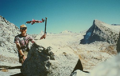 Now another route dilemna assailed me: what did I want to see most? Several
possibilities came to mind: Tamarack Lake, Elizabeth Pass itself, the pass at
Lonely Lake, and the low dead-end overlook due south of Big Bird Lake. As I
worked my way down the east side of the pass I saw a small tarn among the
highest trees in the valley. This sight made my decision: I would set up camp
early, unload most of my gear, and visit the gap by Big Bird. As I approached
the tarn it began to look inappropriately curious, seeming to slant a bit more
than most lakes should. When I reached it the reason became clear: this was a
dark, wet rock that was covered by the trickle of Lonely Lake's last outflow. I
recorded my disappointment and changed my plans on video, then promptly found a
campsite anyway, near a place where the stream provided a good flow through a
narrower channel. Contrary to my video comments, I changed course yet again
and made camp at 2:15. With a much lighter pack I climbed easy terrain to the
crest, where I saw the sights to the north. Directly below me was Big Bird Lake
and its companions, then Deadman Canyon winding northward. On the horizon was
my old friend Mt. Goddard, along with the Palisades and many other famous peaks
on the highest crest. Just to be sure of the best local view I climbed east to
a small hump at around 11200 feet, the high point of my trip. (Had I brought a
little more clothing and my headlamp I would gladly have climbed point 11602 for
maximum effect, but this was good enough under the circumstances). From the
hump I descended to Lonely Lake, at which time I violated one of my wilderness
preferences and broke out the cell phone. I always carry one just in case, with
the battery disconnected; since I was traveling alone this time I thought I'd
try calling my parents to check in. At 10800 feet in the middle of nowhere, I
had full service and reception better than my own front yard! I called home and
told them all was well, then for good measure called my co-workers
(meteorologists) for the latest weather update. All looked good for the
remaining days, so with everyone reassured (including myself) I pulled the plug
again and returned to camp after two hours of fun and great views.
Now another route dilemna assailed me: what did I want to see most? Several
possibilities came to mind: Tamarack Lake, Elizabeth Pass itself, the pass at
Lonely Lake, and the low dead-end overlook due south of Big Bird Lake. As I
worked my way down the east side of the pass I saw a small tarn among the
highest trees in the valley. This sight made my decision: I would set up camp
early, unload most of my gear, and visit the gap by Big Bird. As I approached
the tarn it began to look inappropriately curious, seeming to slant a bit more
than most lakes should. When I reached it the reason became clear: this was a
dark, wet rock that was covered by the trickle of Lonely Lake's last outflow. I
recorded my disappointment and changed my plans on video, then promptly found a
campsite anyway, near a place where the stream provided a good flow through a
narrower channel. Contrary to my video comments, I changed course yet again
and made camp at 2:15. With a much lighter pack I climbed easy terrain to the
crest, where I saw the sights to the north. Directly below me was Big Bird Lake
and its companions, then Deadman Canyon winding northward. On the horizon was
my old friend Mt. Goddard, along with the Palisades and many other famous peaks
on the highest crest. Just to be sure of the best local view I climbed east to
a small hump at around 11200 feet, the high point of my trip. (Had I brought a
little more clothing and my headlamp I would gladly have climbed point 11602 for
maximum effect, but this was good enough under the circumstances). From the
hump I descended to Lonely Lake, at which time I violated one of my wilderness
preferences and broke out the cell phone. I always carry one just in case, with
the battery disconnected; since I was traveling alone this time I thought I'd
try calling my parents to check in. At 10800 feet in the middle of nowhere, I
had full service and reception better than my own front yard! I called home and
told them all was well, then for good measure called my co-workers
(meteorologists) for the latest weather update. All looked good for the
remaining days, so with everyone reassured (including myself) I pulled the plug
again and returned to camp after two hours of fun and great views.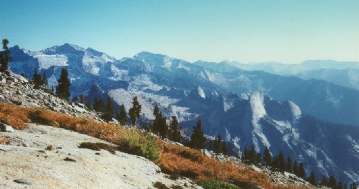 The entertainment wasn't finished though - I had plenty of daylight left! I
cooked up a fine tortellini dinner, then over-pumped my water bottle with my
filter, spraying weak tropical-punch drink over the area. Disgusted with
myself for my neglect, I rinsed off as best I could, wondering what animals would
come to check out the tasty camp. Much to my surprise, the answer was a three-point
mule deer! I had found the slim moon again and was trying to find Venus before
the sun set (though it was already behind the pass from my camp), when a sound
caught my attention. The healthy deer wandered in, tasted a few rocks and my
water bucket, then wandered over to my tent as I spoke softly to him ("Pretty
good punch, ya think? Careful with those antlers, it's a new tent!"). After he
moved on I grabbed my camera and lined him up, but before I could turn off the
flash setting he stiffened then ran off. I fired off a quick shot, wondering
what I had done - then I saw the coyote dash up the hill after him. I took
another picture, then whistled and said hi to the coyote. I suppose I upset the
balance of nature (like the fruit punch hadn't?), but I felt the deer was my
buddy so I gave him an extra chance to get away. I did finally find Venus, but
it was a bit anticlimactic; I went to bed and spent another night not freezing,
even at 10200 feet in October.
The entertainment wasn't finished though - I had plenty of daylight left! I
cooked up a fine tortellini dinner, then over-pumped my water bottle with my
filter, spraying weak tropical-punch drink over the area. Disgusted with
myself for my neglect, I rinsed off as best I could, wondering what animals would
come to check out the tasty camp. Much to my surprise, the answer was a three-point
mule deer! I had found the slim moon again and was trying to find Venus before
the sun set (though it was already behind the pass from my camp), when a sound
caught my attention. The healthy deer wandered in, tasted a few rocks and my
water bucket, then wandered over to my tent as I spoke softly to him ("Pretty
good punch, ya think? Careful with those antlers, it's a new tent!"). After he
moved on I grabbed my camera and lined him up, but before I could turn off the
flash setting he stiffened then ran off. I fired off a quick shot, wondering
what I had done - then I saw the coyote dash up the hill after him. I took
another picture, then whistled and said hi to the coyote. I suppose I upset the
balance of nature (like the fruit punch hadn't?), but I felt the deer was my
buddy so I gave him an extra chance to get away. I did finally find Venus, but
it was a bit anticlimactic; I went to bed and spent another night not freezing,
even at 10200 feet in October.
Another day, another 3-point buck checking out camp - this time while my water
was heating for breakfast. I waited for the sun to find me as I drankmy cocoa-mocha
and planned my day. Needing to make as many miles as possible to simplify day
four, I reluctantly dropped Tamarack Lake from the route. I was concerned
about finding the Elizabeth Pass trail below me, as several guidebooks remarked
on its occasional faintness, but by 9AM I was on my way down the valley with
everything planned. I should encounter the trail at the same elevation as the
lowest of the Hamilton Domes across the valley, so as it rose to meet me I
scanned the area closely. In hindsight, I should have stayed further from the
creek, as its scouring had left nothing but granite sheets on the valley floor:
a perfect place to hide a trail! I continued down to the brink of the hanging
valley, then veered right toward where the trail should appear. At last I found
a gully with prints, an awful trail but clearly used before. I scrambled and
slid down, wondering how a trail could be so bad, aiming for the clearer path
which was visible near Lone Pine Creek. Just before reaching what looked like
impenetrable manzanita shrubs, I saw a wonderful and awful sight: the REAL
Elizabeth Pass Trail, descending before me from further right. I had just
committed a big-time cutting of swithbacks, and only the fact that I had
followed a slightly beaten path made me less appalled by my work. Finally,
though, the cross-country section of the trip was over, and I could
concentrate on mileage and not just travel.
It would take a long time for the sun to find me in this secluded campsite, and
I was not planning to wait for it; I was out of the tent at 6:45. Thankfully,
my sleeping gear was not damp this morning, so I had no need to worry about
soaking my pack. Somehow it still took a long time to get started, but before
8AM I was on the move. Hoping to be on the road (and showered!) by noon, I
immediately hit the Cutoff junction. Despite my hopes of a gentler route it
crawled steeply up the hill, occasionally revealing views of the Great Western
Divide through the trees. It crested at a fine viewpoint of everything from Mt.
Stewart to the Castle Rocks, then turned a corner - and time stopped.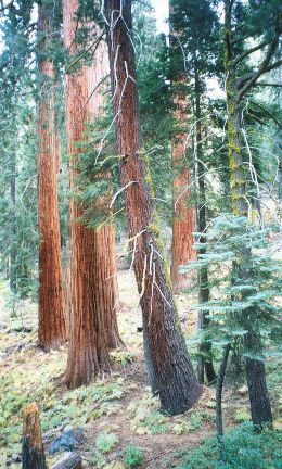 Even though I knew they would be there, the stand of giant sequoia were
tremendous: huge, colorful, ancient, with a rich not-quite-cedar aroma and
photogenic quality that dramatically slowed my pace. The trail wound directly
among the behemoths, totally immersing me in their aura. It all seemed so..
well, tree-ish. I again reverted to Tolkein terminology to describe the place,
a Fangorn Forest in the real world. My film and batteries were further depleted
here as each turning brought a new view that could not be passed by. I kept
thinking of how I would describe this place when I returned to family and
friends, and for a few moments was lost in thought [another
backpacking first? :] -- and suddenly they were gone! The rusty trunks
were mere ponderosa, and looking back the grove of sequoia could not be seen.
Not Fangorn, then, but Lothlorien and its Mallorn trees that stopped
abruptly at the border. Thankfully, a few minutes later I turned another
corner, and the enchanted trees were around me again, taking more film but
supplying feelings beyond description. They came and went a few more times,
once in a fire-stricken area where their trunks were scorched with no obvious
damage to the overall tree while fir-trunks lay black on the ground. I reached
the Alta Trail and began climbing again, and soon they were lost again - but
clearly they would remain long in memory (and on film).
Even though I knew they would be there, the stand of giant sequoia were
tremendous: huge, colorful, ancient, with a rich not-quite-cedar aroma and
photogenic quality that dramatically slowed my pace. The trail wound directly
among the behemoths, totally immersing me in their aura. It all seemed so..
well, tree-ish. I again reverted to Tolkein terminology to describe the place,
a Fangorn Forest in the real world. My film and batteries were further depleted
here as each turning brought a new view that could not be passed by. I kept
thinking of how I would describe this place when I returned to family and
friends, and for a few moments was lost in thought [another
backpacking first? :] -- and suddenly they were gone! The rusty trunks
were mere ponderosa, and looking back the grove of sequoia could not be seen.
Not Fangorn, then, but Lothlorien and its Mallorn trees that stopped
abruptly at the border. Thankfully, a few minutes later I turned another
corner, and the enchanted trees were around me again, taking more film but
supplying feelings beyond description. They came and went a few more times,
once in a fire-stricken area where their trunks were scorched with no obvious
damage to the overall tree while fir-trunks lay black on the ground. I reached
the Alta Trail and began climbing again, and soon they were lost again - but
clearly they would remain long in memory (and on film).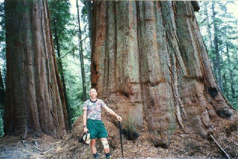
The home stretch at last! I worked up yet another uphill slope, munching on my
breakfast bars, then hit the last junction off the Alta Trail. More downhill,
which my weary feet pointed out to me in strong terms, then a pretty meadow.
Suddenly I'm not alone: a coyote is staring at me from further up the trail!
His tail is thicker than his midsection, so I suggested he look for some good
carrion and moved forward. He continued up the trail ahead of me, occasionally
stopping to look back. "Yes, I'm still following you, and I will until you
leave the trail!" I took my final two pictures of him, and as the film wound
back into the can I pulled out the video camera for good measure. At that, he
slipped into the woods beside the trail, and my path was clear again. Within
fifteen minutes, the thankfully-unmolested car appeared: at 10:45 on day four,
my trip was over.
Party time! I peeled off my boots and put my feet into their promised reward, a pair of sandals and NO SOCKS. I then retrieved my supplies from the bear can, noting with interest that the food bag was torn open by rodents and the pretzels had been just slightly invaded (no accounting for taste). The beer was in perfect condition, as I found out quickly (I later declared it tied for my Best Beer Ever, as good as the 1979 beer that began the post-hike tradition. The trailhead was much more popular now, with a dozen cars in the lot and several hikers preparing to move. I had one of them shoot me with a fresh roll of film, beer and pretzels in hand, then stuffed everything in the car and headed for Lodgepole and its shower-stalls. Shortly after noon, I hit the southward road, stopping for a few minutes to limp around the General Sherman tree and other members of the Giant Forest grove. They were again spectacular, but the reward of hiking through them after a day or two above all trees made the original encounter the more precious. Soon I was losing elevation in spectacular fashion, reaching Three Rivers (elevation 800') in a ridiculously short time. Onward to the next phase of my autumn 2002 vacation, with sure knowledge that I am Not a Fraud!!
| what worked, what didn't | The Adventure Continues! |
|---|