Flashback: the 1989 High Sierra Expedition
Flashback: the 1989 High Sierra Expedition
My closest approach to the High Sierra was in 1975, when my parents and I drove up the road toward Whitney Portal. The car struggled mightily due to elevation and a faulty fuel-intake system, so we stopped in the Alabama Hills and took a few photos of Mt. Whitney and the neighborhood. I wasn't even totally sure which was Whitney at the time, and one of my stronger memories was that I left my sunglasses on top of the car when we turned around.
By 1989, Scott knew these peaks well. He had already hiked the length of the John Muir Trail (JMT) on previous journeys, and Wally joined him on trips at least once. Scott's 1988 tour took him off the JMT for new scenery, and he retreated down Taboose Pass with unfinished work. The 1989 event would return up Taboose Pass and turn south, finishing up seventy-plus miles later at Whitney Portal. I have no sure recollection of how I picked up an invitation for the trip, but the thought of seeing the High Sierra up close was intriguing. I was in good shape and had decent equipment, but had no experience to match my two companions, since this would double my previous long hike and take me above my previous highest elevation (11900' in the Wind Rivers) - on several consecutive days! I did everything I could think of to get my body ready for the eight-day trip, and I examined our route carefully in advance.
The drive from Portland is long but highly scenic, with the Cascades on day one and northern Sierra on day two. We took two vehicles to speed up our return trip, since our starting and ending points were far apart. The late-August timing was past Scott's usual schedule, so even he would learn something on this hike. By late afternoon on day two I was again in the Alabama Hills, driving a reluctant car uphill; this car was ready for it, and we camped out at 8400-foot Whitney Portal under partly-cloudy skies. Scott had warned me that thunderstorms were fairly reliable for at least one day of a long Sierra trip, so the clouds were not too unsettling. We spent the night breathing the oxygen-short air, which helped us prepare our bodies for the next week's workout.
 farewell car, hello wilderness
|
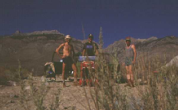
Leaving my car at the Portal, we piled into Wally's
car for the drive back north. The trailhead was adjacent to the
middle of nowhere; it was the stereotypical rain-shadow terrain,
with small shrubs and no trees to deflect the hot sun east of
the great mountains. After a group photo we put on our burdens
and headed west into the hills. The hills hung back, allowing
us to baste for an hour or more before reaching the steeper slopes.
With little water and no shade, the first hours were punishing,
but Taboose is well known for that - which is why it's not a popular
trailhead! When we reached shade and water (within twenty feet
of each other), we drank heartily and pulled out some lunch. We
later worked our way further up the steep canyon, outflanking
a noisy waterfall in the late afternoon. As twilight drew close
we found a slanted but pleasant campsite, and collapsed in place
for the night. I chose to bring no tent with me, confident that
I could beg for room in one of their tents, but the cloudless
skies kept us all out in the open this night. At sunrise a sliver
of moon was seen above the hills in the east, reminding me that
I had forsaken a weekend of amateur astronomy for this hike; I
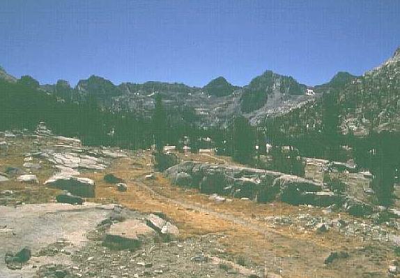
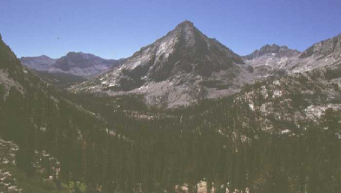
was pretty sure I had done the right thing... Early on day two we were on our way upstream again. The slope relented a bit here, and the high meadow was a pleasant change of pace. The slope and rock returned soon enough, but I could see Scott and Wally ahead of me (a common sight!) resting at the pass. The view from Taboose Pass is amazing - sharp peaks, small trees in clumps at their bases, and the South Fork Kings River canyon swallowing up the rest of the view. Only once before had I been in such a desolate spot, on the Lizard Head trail ten years earlier; it was great to be back. We partied a bit at the pass (it was Scott's 40th birthday, after all) then headed downhill toward the Muir Trail. Today's hike was a short one, and the destination - Bench Lake - was visible from the pass. We joined the JMT for no more than ten minutes, then veered off on the spur trail to Bench Lake. The view of aptly-named Arrow Peak towering over the lake was a wondrous sight, and we dined near the lakeshore. Scott commented that this was the first time on any of his trips that a half-hour in the shade became too cool: the heat of summer was over at this elevation! We camped among the rocks north of the lake, and again the weather cooperated. |
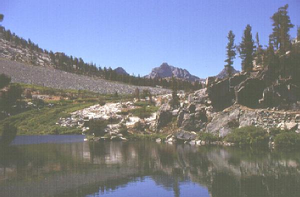 Dollar Lake and points south
|
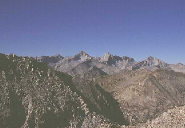
Day three found us crunching over frosted turf on
the JMT, southbound to a new personal elevation record: 12100-foot
Pinchot Pass. The lakes on the north side of the pass were sparkling
foreground objects in views toward Mather Pass and Mt. Ruskin,
and the black massif of the Palisades rose to our north as we
gained elevation. We finally reached the pass and relaxed a while,
then wandered toward Twin Lakes -- but first, an announcement
from Scott and Wally. Work issues were pressing Wally at the time,
and they casually mentioned that it would be good if the trip
were shortened - in time, NOT length - by one day. It was an interesting
concept, to put it mildly, and I contemplated where to add mileage
as we wandered toward Mt. Cedric Wright and the Woods Creek valley.
We lunched where we thought we would be camping, then proceeded
downstream toward the low point of the hike at 8400 feet. Darkness
caught us as we ascended again, foiling our attempt to reach the
Rae Lakes area. Without a decent tree to hang our food from, the
others suggested dangling it over a precipice with a roaring creek
below. It worried me quite a bit, but their confidence relaxed
me enough to agree. The weather was getting monotonous in its
placidity; I had no complaints!
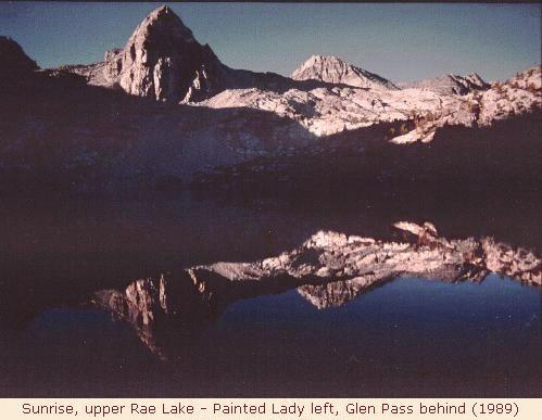
Day four was the last day of August, and our first attempt to shorten the trip didn't work to our benefit. Rae Lakes were only a few miles upstream, and it was a spectacular spot, but stopping here would put us back on the old schedule. We walked and talked, eating lunch there and checking the maps. As the slow one, my word was the tiebreaker: should we continue over Glen Pass and risk afternoon storms on that and Forester Pass the next day, or could I turn the last three days into two long ones? I voted for the second option, so we camped at upper Rae Lake and rested up for the future marathon. Scott and Wally bickered about the decision, but both reassured me that by day four they always found something to argue about. It was another glorious day of sunshine, and the bear-boxes held our food safely while we slept under the stars. Day five was Moving Day, where a few extra miles would put us in perfect position for a huge sixth day. We passed the uppermost Rae Lake as the sun lit the peaks around Glen Pass; the view through my 24mm lens was crowded but spectacular! I shifted into extreme low gear on the interminable route to Glen Pass, where the trail-blazers must have been inspired by the April 1906 seismograph reading in San Francisco. The view south toward Mt. Brewer and the Kings-Kern Divide was thrilling, although I knew Forester Pass had to cross that high area. A steep drop and a gradual curve brought us in view of the next valley, and our first good view west toward Fresno. A few clouds gripped the horizon, the first we'd seen in days. As we descended to lovely, forested (!) Vidette Meadow the wispy cirrus clouds made their move, adding a touch of variety to the sky without posing a serious threat. We wandered up bubbly Bubbs Creek past the Center Basin junction. Scott stayed near me and urged me on a few more miles, but I thought that Wally was behind us. As the cirrus clouds mutated into altostratus, we climbed up to the last of the trees, where Wally was looking at the sky and reaching for his tent. While the sky was still not particularly threatening, it was looking unsettled, so I successfully begged a spot in a tent for the night. We slept at about 11200 feet; a week before it would nearly have been an elevation record, but here it was just another campsite. |
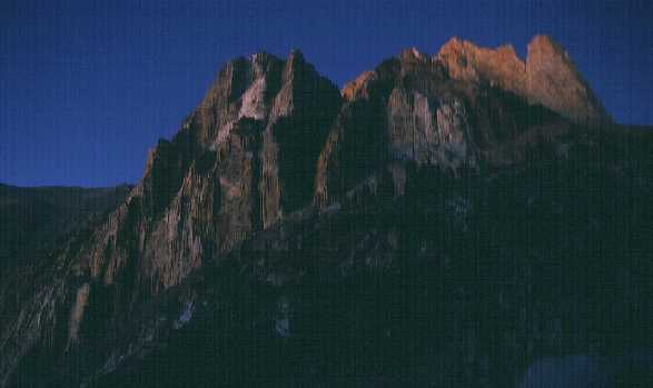
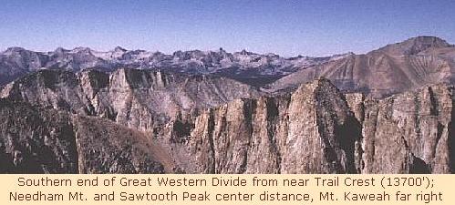
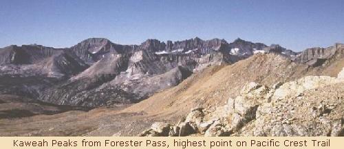 Kaweah Peaks from Forester Pass
| Day Six - the Big One. We awoke to clear skies and a frosty sunrise on the peaks, ate quickly and headed toward yet another elevation record. At 13200 feet Forester Pass was the high point of the Pacific Crest Trail, but we had higher plans still on the JMT! By late morning we had abandoned nearly all other life-forms and crossed Forester Pass. The Palisades were still visible in the far north, but the south view over a cliff etched with switchbacks was truly spectacular. Having traversed Kings Canyon park since Taboose Pass, we now entered Sequoia National Park on a trail that wound down the cliff to the high tundra at the headwaters of Tyndall Creek. We seemed to go on for hours before encountering so much as a shrub, but we finally reached a clump of trees near the Tyndall Creek crossing. Another uphill climb leveled off on Bighorn Plateau, the scheduled end to day six. We breezed on past, crossing Wallace Creek and climbing again to Sandy Meadow late in the day. We departed from the Crest Trail near Crabtree Meadow and turned uphill one last time. As daylight waned we reached the Crabtree ranger station and camped nearby. We had gone more than halfway to the car this day, but big things awaited the sunrise... |
|---|---|
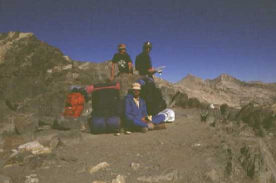
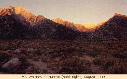
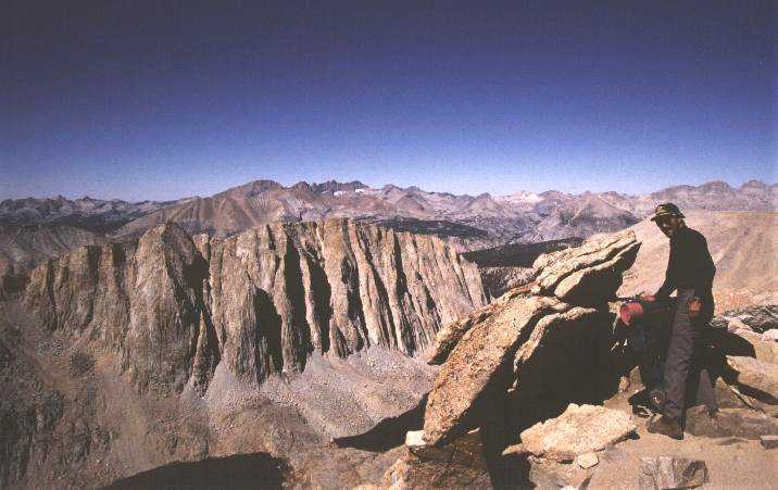 Scott prepares for Mt. Whitney
| The seventh day was a Sunday, but not one of rest. Rising ahead of the sun, we had reached Timberline Lake when daylight bounced off the Kaweah Peaks behind us. The sun would take a long time to illuminate this area, and we passed campsites at Guitar Lake in the dim light and reached the switchbacks that led to Trail Crest, yet another elevation record at 13700 feet. That climb conspired with the previous day's toil to drain my strength, and the tilted rubble alongside the steep trail kept me hoping that this area be spared of any earthquakes for at least another two hours. We finally reached the Mt. Whitney summit trail junction, and suddenly other people were near us - it had been a long time since we saw more than three other people! In a decision that confirmed my dubious sanity forever, I chose not to climb Whitney, noting that Scott and Wally might reach the summit, relax a while, and STILL beat me to the car. They moved north while I struggled south, reaching Trail Crest late in the morning of the day before Labor Day, and unhappily rejoined civilization on the spot. Dozens of people met my gaze, few of whom carried full-size packs. A boom-box blared while a 'portable' jackhammer beat on the granite just below the pass. People of all ages and fitness levels sped, crawled or stood gasping on the trail. It was an odd anti-climax after such an amazing week of work, but seldom do backpacking trips end the way a hiker would choose (although the beer in the car at the Wind Rivers still stands out). I limped steadily downhill, accompanied by a friendly man who chatted on regardless of my general silence. A few cumulus clouds appeared, the first since my previous visit to Whitney Portal a week before; they were non-aggressive and added to the sky's character so I allowed them to stay. Two college-age women, both named Jennifer, joined us on the last miles; they had just dropped off a fellow Stanford student as she entered the wilderness. I took their picture by the wilderness marker, confident that Scott and Wally would need proof that I was not hallucinating. I reached my car, searched a while for long-forsaken keys, and sat in a padded car seat. When the others arrived only a half-hour later, we celebrated with a beer and another group photo before starting the engine and heading for Wally's car, then back to the town of Lone Pine and real beds. After another breakfast at the Sportsman Cafe, we parted company - they headed north back to Portland, while I drove through Death Valley (90° at 9am!) and spent the night in a quiet, forsaken town known by the quaint name of Las Vegas. As I pulled into town, the new Aerosmith song "Love in an Elevator" played on the stereo; yup, I was out of the wilderness. |